IMAGES TAKEN NEAR TO
Keelmount Grange, CRAIGAVON, BT62 1UE
Introduction
This page details the photographs taken nearby to Keelmount Grange, BT62 1UE by members of the Geograph project.
The Geograph project started in 2005 with the aim of publishing, organising and preserving representative images for every square kilometre of Great Britain, Ireland and the Isle of Man.

There are currently over 7.5m images from over14,400 individuals and you can help contribute to the project by visiting https://www.geograph.org.uk
Image Map
Images are licensed for reuse under creativecommons.org/licenses/by-sa/2.0
Notes
- Clicking on the map will re-center to the selected point.
- The higher the marker number, the further away the image location is from the centre of the postcode.
Image Listing (9 Images Found)
Images are licensed for reuse under creativecommons.org/licenses/by-sa/2.0
Image
Details
Distance
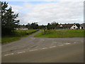
1
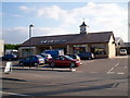
Near Portadown
Service station and mini-market with post office on Moy Road at Scotch Street.
Image: © Robert Ashby
Taken: 23 Aug 2017
0.07 miles
2
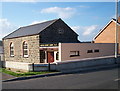
Scotch Street Gospel Hall, Derrylettiff Road
Image: © P Flannagan
Taken: 13 Oct 2007
0.09 miles
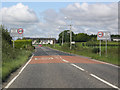
3
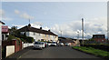
Stewart's Terrace
Looking SE towards Scotch Street.
Image: © Robert Ashby
Taken: 23 Aug 2017
0.10 miles
5
Richmount Controlled Primary School
In Scotch street.
Image: © Brian Shaw
Taken: 19 Jul 2006
0.16 miles
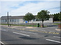
6
Scotch Street
Located on the main Portadown to Moy Road a few miles outside Portadown.
Image: © Terry Stewart
Taken: 21 Aug 2007
0.16 miles
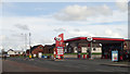
7
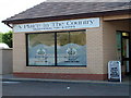
A Selection of Small Shops at Scotch Street, Moy Road, Portadown
Image: © P Flannagan
Taken: 13 Oct 2007
0.16 miles
8
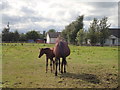
Near Portadown (2)
Mare and foal in a field beside Derrylettiff Road.
Image: © Robert Ashby
Taken: 23 Aug 2017
0.21 miles