IMAGES TAKEN NEAR TO
Derrycush Road, CRAIGAVON, BT62 1TU
Introduction
This page details the photographs taken nearby to Derrycush Road, BT62 1TU by members of the Geograph project.
The Geograph project started in 2005 with the aim of publishing, organising and preserving representative images for every square kilometre of Great Britain, Ireland and the Isle of Man.

There are currently over 7.5m images from over14,400 individuals and you can help contribute to the project by visiting https://www.geograph.org.uk
Image Map
Images are licensed for reuse under creativecommons.org/licenses/by-sa/2.0
Notes
- Clicking on the map will re-center to the selected point.
- The higher the marker number, the further away the image location is from the centre of the postcode.
Image Listing (6 Images Found)
Images are licensed for reuse under creativecommons.org/licenses/by-sa/2.0
Image
Details
Distance
1
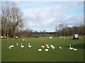
Free-range Geese, Derrycush Road, Portadown
Image: © P Flannagan
Taken: 22 Mar 2008
0.14 miles
2
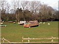
Shelter (upturned boat) for Sheep, Farlough Road, Portadown
Image: © P Flannagan
Taken: 22 Mar 2008
0.15 miles
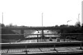
4
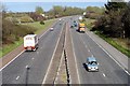
Junction 12 The Birches
M1 Motorway at Junction 12 The Birches, looking towards Portadown. The lefthand lane leads to Portadown and Belfast, while the righthand lane leads to Dungannon.
Image: © Wilson Adams
Taken: 11 Apr 2007
0.18 miles
5
M1 Motorway Junction 12 The Birches
Looking towards Dungannon
Image: © Wilson Adams
Taken: 11 Apr 2007
0.18 miles
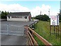
6
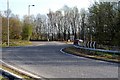
A Roundabout Exit
Exit to the left leading to Portadown, on the A4 Dungannon Road
Image: © Wilson Adams
Taken: 11 Apr 2007
0.18 miles