IMAGES TAKEN NEAR TO
Derrylileagh Road, CRAIGAVON, BT62 1TE
Introduction
This page details the photographs taken nearby to Derrylileagh Road, BT62 1TE by members of the Geograph project.
The Geograph project started in 2005 with the aim of publishing, organising and preserving representative images for every square kilometre of Great Britain, Ireland and the Isle of Man.

There are currently over 7.5m images from over14,400 individuals and you can help contribute to the project by visiting https://www.geograph.org.uk
Image Map
Images are licensed for reuse under creativecommons.org/licenses/by-sa/2.0
Notes
- Clicking on the map will re-center to the selected point.
- The higher the marker number, the further away the image location is from the centre of the postcode.
Image Listing (4 Images Found)
Images are licensed for reuse under creativecommons.org/licenses/by-sa/2.0
Image
Details
Distance
1
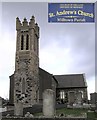
St. Andrew's Church of Ireland, Milltown Parish
It is in the Diocese of Armagh
Image: © Kenneth Allen
Taken: 14 Nov 2006
0.16 miles
2
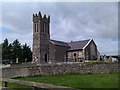
St Andrew's Parish Church of Ireland
Pictured along Maghery Road
Image: © Kenneth Allen
Taken: 2 Sep 2012
0.16 miles
3
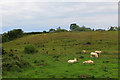
Taking it easy
Cows having a lazy day. Charolais, I think.
Image: © Robert Ashby
Taken: 24 Jun 2015
0.19 miles
4
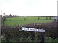
The Wood Road
It is located to the south of Maghery
Image: © Kenneth Allen
Taken: 14 Nov 2006
0.20 miles