IMAGES TAKEN NEAR TO
Tartaraghan Road, CRAIGAVON, BT62 1RH
Introduction
This page details the photographs taken nearby to Tartaraghan Road, BT62 1RH by members of the Geograph project.
The Geograph project started in 2005 with the aim of publishing, organising and preserving representative images for every square kilometre of Great Britain, Ireland and the Isle of Man.

There are currently over 7.5m images from over14,400 individuals and you can help contribute to the project by visiting https://www.geograph.org.uk
Image Map
Images are licensed for reuse under creativecommons.org/licenses/by-sa/2.0
Notes
- Clicking on the map will re-center to the selected point.
- The higher the marker number, the further away the image location is from the centre of the postcode.
Image Listing (13 Images Found)
Images are licensed for reuse under creativecommons.org/licenses/by-sa/2.0
Image
Details
Distance
3
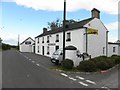
The Head O' The Road, Tartaraghan
The Head O' The Road is a family-run authentic country pub in Co Armagh which is over 75 years old.
Image: © Kenneth Allen
Taken: 28 Jun 2011
0.10 miles
4
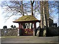
Lychgate of Tartaraghan Parish Church
A Lychgate is a covered open structure, found at a church gate. It normally consists of four or six oak posts embedded in the ground in a rectangular shape. On top of this are a number of beams to hold a steeply sloping straight pitched roof covered in wooden or clay peg tiles. The name is derived from the Saxon Lych meaning "corpse" and gate meaning entrance. Hence corpse entrance.
The lychgates were built from about the mid 15th century. It was the custom at the time for priests to conduct the first part of the funeral service under its shelter. During medieval times the rich were the only people buried in coffins. The poor were carried to the lychgate and placed on a stone or wooden table covered in a shroud before burial. See Image
Image: © P Flannagan
Taken: 22 Feb 2007
0.11 miles
5
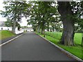
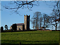
Tree-lined avenue, Tartaraghan Parish Church
It is heading towards the main road
Image: © Kenneth Allen
Taken: 28 Jun 2011
0.13 miles
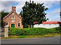
6
Cottage, Tarthlogue, Breagh
It belongs to the adjoining Tartaraghan Parish Church
Image: © Kenneth Allen
Taken: 28 Jun 2011
0.16 miles
7
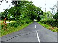
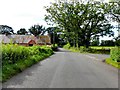
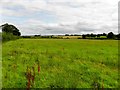
Cherryville Road, Breagh Lower
Heading NNE from Tartaraghan Road
Image: © Kenneth Allen
Taken: 2 Sep 2012
0.16 miles
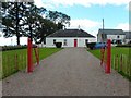
8
Tartaraghan Masonic Hall
It is located along Tartaraghan Road - the date on the plaque is 1893
Image: © Kenneth Allen
Taken: 2 Sep 2012
0.17 miles
10
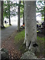
Unusual tree at Tartaraghan Parish Church
It is located beside the Lychgate. Included in the trunk near the base is a "bowl" holding water.
Image: © Kenneth Allen
Taken: 28 Jun 2011
0.20 miles