IMAGES TAKEN NEAR TO
Derrymacfall Road, CRAIGAVON, BT62 1PS
Introduction
This page details the photographs taken nearby to Derrymacfall Road, BT62 1PS by members of the Geograph project.
The Geograph project started in 2005 with the aim of publishing, organising and preserving representative images for every square kilometre of Great Britain, Ireland and the Isle of Man.

There are currently over 7.5m images from over14,400 individuals and you can help contribute to the project by visiting https://www.geograph.org.uk
Image Map
Images are licensed for reuse under creativecommons.org/licenses/by-sa/2.0
Notes
- Clicking on the map will re-center to the selected point.
- The higher the marker number, the further away the image location is from the centre of the postcode.
Image Listing (5 Images Found)
Images are licensed for reuse under creativecommons.org/licenses/by-sa/2.0
Image
Details
Distance
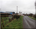
1
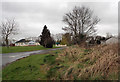
Derrymacfall Road
Just south of the M1 near Portadown.
Image: © Robert Ashby
Taken: 22 Mar 2017
0.10 miles
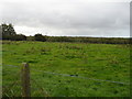

4
Derrymacfall Road
South of the M1 near Portadown.
Image: © Robert Ashby
Taken: 22 Mar 2017
0.22 miles
5
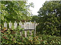
No through Road
This country lane lost its claim to any importance after the road builders constructed the M1 motorway. Just to underline the point there's no way you're going to cross - palisade fencing was erected to make sure. A car can be seen travelling on the Eastbound carriageway (to Belfast).
Image: © Raymond Okonski
Taken: 25 Sep 2007
0.23 miles