IMAGES TAKEN NEAR TO
The Beeches, CRAIGAVON, BT62 1AY
Introduction
This page details the photographs taken nearby to The Beeches, BT62 1AY by members of the Geograph project.
The Geograph project started in 2005 with the aim of publishing, organising and preserving representative images for every square kilometre of Great Britain, Ireland and the Isle of Man.

There are currently over 7.5m images from over14,400 individuals and you can help contribute to the project by visiting https://www.geograph.org.uk
Image Map
Images are licensed for reuse under creativecommons.org/licenses/by-sa/2.0
Notes
- Clicking on the map will re-center to the selected point.
- The higher the marker number, the further away the image location is from the centre of the postcode.
Image Listing (30 Images Found)
Images are licensed for reuse under creativecommons.org/licenses/by-sa/2.0
Image
Details
Distance
1
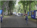
Country comes to town fair 2009 Portadown
Peopl'es Park
Image: © HENRY CLARK
Taken: 19 Sep 2009
0.04 miles
2
Country comes to town fair 2009 Portadown
People's Park
Image: © HENRY CLARK
Taken: 19 Sep 2009
0.08 miles
4
Montague Street leading on to the Corcrain Road, Portadown.
Image: © P Flannagan
Taken: 23 Aug 2007
0.17 miles
5
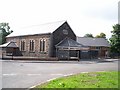
Epworth Methodist Church, Montague Street, Portadown
During the latter part of the nineteenth century a National School was built in Edgarstown through the generosity of Mr Wakefield and the Right Hon. Thomas Shillington. In this building, a service was held every Sunday afternoon and a Sunday School established. When the National School was closed by the Educational Authorities in 1922, the building was re-named and known as Epworth Hall. Since then, extensive renovations have been carried out and the normal church services and activities continue.
Image: © P Flannagan
Taken: 23 Aug 2007
0.17 miles
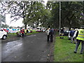
6
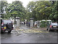
Entrance to the People's Park, Portadown
Image: © HENRY CLARK
Taken: 19 Sep 2009
0.18 miles
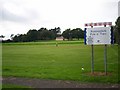
7
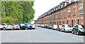
Park Road, Portadown
A street, between the park (left) and the railway (behind the houses), running from Obins Street to the Garvaghy Road. Many of the houses have attics. Image shows a similar view in September 2009.
Image: © Albert Bridge
Taken: 20 May 2013
0.20 miles
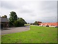
9
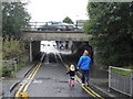
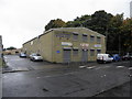
The Tunnel leading to Obin Street
The bridge carries Northway Bypass
Image: © HENRY CLARK
Taken: 19 Sep 2009
0.22 miles
10
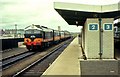
Portadown (Craigavon West) station
The old Ulster Railway station at Watson Street closed in 1970 to make way for the Northway. It was replaced by this station with the unwieldy name “Portadown (Craigavon West)”. The train is the 08.30 Dublin – Belfast “Enterprise”. When the photo was taken the bombing campaign had dramatically reduced the number of passengers travelling on cross-border trains. One generating van (CIE locomotives were non-ETH), one first-class coach, a dining car and three standards were more than sufficient.
Image: © Albert Bridge
Taken: 10 Jun 1972
0.22 miles