IMAGES TAKEN NEAR TO
The Mall East, ARMAGH, BT61 9BE
Introduction
This page details the photographs taken nearby to The Mall East, BT61 9BE by members of the Geograph project.
The Geograph project started in 2005 with the aim of publishing, organising and preserving representative images for every square kilometre of Great Britain, Ireland and the Isle of Man.

There are currently over 7.5m images from over14,400 individuals and you can help contribute to the project by visiting https://www.geograph.org.uk
Image Map
Images are licensed for reuse under creativecommons.org/licenses/by-sa/2.0
Notes
- Clicking on the map will re-center to the selected point.
- The higher the marker number, the further away the image location is from the centre of the postcode.
Image Listing (384 Images Found)
Images are licensed for reuse under creativecommons.org/licenses/by-sa/2.0
Image
Details
Distance
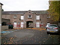
1
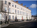
Charlemont Place, Armagh
When the Mall was developed as public walks in 1798, the racecourse having been removed from the area, it became one of the most desirable residential areas in Armagh. The fine houses of Charlemont Place were built on the east side between 1820 and 1840. The Southern Education and Library Board now occupy all five houses.
Image: © P Flannagan
Taken: 9 Mar 2008
0.02 miles
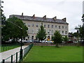
2
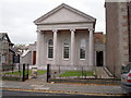
The Armagh County Museum, The Mall East, Armagh
This two storey building, with three tall arched windows behind the ashlar limestone tetrastyle lonic portico and matching doorways in screen walls at each side of the portico, was built in 1834. It became the Armagh County Museum in 1931. An exterior cleaning of the building has just been completed in 2007.
Image: © P Flannagan
Taken: 10 Oct 2007
0.03 miles
3
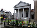
Armagh County Museum
Pictured beside The Mall
Image: © Kenneth Allen
Taken: 25 Jun 2014
0.03 miles
4
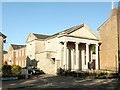
Armagh County Museum, Mall East
This classical building began life in 1834 as the Charlemount National School. In 1856 it was transferred by Lord Charlemount to the Armagh Natural History and Philosophical Society as their meeting room. Over the years extensions were added to the back of the original building, which housed an art school. In 1931 the property was acquired by Armagh County Council and has since then housed the Armagh County Museum and Library Headquarters.
Image: © Eric Jones
Taken: 3 Jun 2016
0.04 miles
6
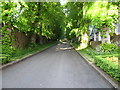
Church Walk, Armagh
This links the Mall with St Mark's Church. The Walk is also known as Grantham Gardens.
Image: © Eric Jones
Taken: 3 Jun 2016
0.05 miles
7
View north along the upper half of Mall East
Image: © Eric Jones
Taken: 3 Jun 2016
0.05 miles
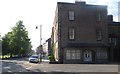
8
1-5 Charlemont Place, Mall East
These elegant town houses were built as a speculative venture by Lord Charlemont in 1827. They became the homes of professional, military and church elite. In 1990 the block was purchased by the South Eastern Education and Library Board (SEELB).
Image: © Eric Jones
Taken: 2 Jun 2016
0.06 miles
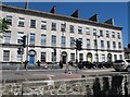
10
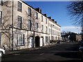
Georgian Houses, Beresford Row, The Mall East, Armagh
Beresford Row is named in honour of Lord John George Beresford, Archbishop of Armagh from 1822-1862. These houses were built at various dates between 1826 and 1840.
Image: © P Flannagan
Taken: 4 Feb 2008
0.06 miles