IMAGES TAKEN NEAR TO
Ballytyrone Road, ARMAGH, BT61 8QA
Introduction
This page details the photographs taken nearby to Ballytyrone Road, BT61 8QA by members of the Geograph project.
The Geograph project started in 2005 with the aim of publishing, organising and preserving representative images for every square kilometre of Great Britain, Ireland and the Isle of Man.

There are currently over 7.5m images from over14,400 individuals and you can help contribute to the project by visiting https://www.geograph.org.uk
Image Map
Images are licensed for reuse under creativecommons.org/licenses/by-sa/2.0
Notes
- Clicking on the map will re-center to the selected point.
- The higher the marker number, the further away the image location is from the centre of the postcode.
Image Listing (2 Images Found)
Images are licensed for reuse under creativecommons.org/licenses/by-sa/2.0
Image
Details
Distance
1
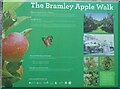
The Bramley Apple Walk information board at Loughgall Country Park
An information board attached to The Walled Garden wall in Loughgall Country Park, County Armagh, Northern Ireland.
Image: © P Webb
Taken: 5 Apr 2021
0.24 miles
2
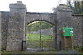
Walled Garden gates, Loughgall Country Park, Co Armagh, Northern Ireland
The centre of the gates are shaped like an apple due to this being in the apple growing area of County Armagh.
Image: © P Webb
Taken: 20 Oct 2017
0.25 miles