IMAGES TAKEN NEAR TO
Annahugh Park, ARMAGH, BT61 8PF
Introduction
This page details the photographs taken nearby to Annahugh Park, BT61 8PF by members of the Geograph project.
The Geograph project started in 2005 with the aim of publishing, organising and preserving representative images for every square kilometre of Great Britain, Ireland and the Isle of Man.

There are currently over 7.5m images from over14,400 individuals and you can help contribute to the project by visiting https://www.geograph.org.uk
Image Map
Images are licensed for reuse under creativecommons.org/licenses/by-sa/2.0
Notes
- Clicking on the map will re-center to the selected point.
- The higher the marker number, the further away the image location is from the centre of the postcode.
Image Listing (3 Images Found)
Images are licensed for reuse under creativecommons.org/licenses/by-sa/2.0
Image
Details
Distance
1
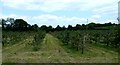
Apple trees, Co Armagh
An orchard of young apple trees at the end of June, one of many along the Red Lion Road between Loughgall and Portadown, . The blossoms have gone and soon the fruit will start to appear.
Image: © Robert Ashby
Taken: 26 Jun 2013
0.17 miles
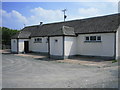
3
Attractive Rural Housing Development, Annaghugh, Loughgall.
Image: © P Flannagan
Taken: 14 Sep 2007
0.19 miles