IMAGES TAKEN NEAR TO
Kilmore Road, ARMAGH, BT61 8NW
Introduction
This page details the photographs taken nearby to Kilmore Road, BT61 8NW by members of the Geograph project.
The Geograph project started in 2005 with the aim of publishing, organising and preserving representative images for every square kilometre of Great Britain, Ireland and the Isle of Man.

There are currently over 7.5m images from over14,400 individuals and you can help contribute to the project by visiting https://www.geograph.org.uk
Image Map
Images are licensed for reuse under creativecommons.org/licenses/by-sa/2.0
Notes
- Clicking on the map will re-center to the selected point.
- The higher the marker number, the further away the image location is from the centre of the postcode.
Image Listing (5 Images Found)
Images are licensed for reuse under creativecommons.org/licenses/by-sa/2.0
Image
Details
Distance
1
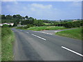
T Junction
Annaboe Road joins Kilmore Road (looking towards Drummannon).
Image: © Brian Shaw
Taken: 5 Jul 2006
0.11 miles
2
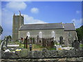
St Aidan's Parish Church, Kilmore
Church of Ireland parish church, rebuilt in 1814. Many places in Ireland are called Kilmore: it means Big Church in Irish.
Image: © Brian Shaw
Taken: 5 Jul 2006
0.11 miles
3
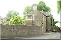
Kilmore School
This building was the school house and closed many years ago.
Image: © William England
Taken: 15 Jul 2009
0.15 miles
4
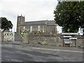
St. Aidan's Parish Church of Ireland, Kilmore
Located at Kilmore Road, it is in the Diocese of Armagh and the Parish of Kilmore
Image: © Kenneth Allen
Taken: 9 Jun 2011
0.18 miles
5
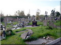
Graveyard, St. Aidan's Church, Kilmacanty Road, Kilmore
Image: © P Flannagan
Taken: 17 Oct 2007
0.25 miles