IMAGES TAKEN NEAR TO
Loughgall Road, ARMAGH, BT61 8EW
Introduction
This page details the photographs taken nearby to Loughgall Road, BT61 8EW by members of the Geograph project.
The Geograph project started in 2005 with the aim of publishing, organising and preserving representative images for every square kilometre of Great Britain, Ireland and the Isle of Man.

There are currently over 7.5m images from over14,400 individuals and you can help contribute to the project by visiting https://www.geograph.org.uk
Image Map
Images are licensed for reuse under creativecommons.org/licenses/by-sa/2.0
Notes
- Clicking on the map will re-center to the selected point.
- The higher the marker number, the further away the image location is from the centre of the postcode.
Image Listing (3 Images Found)
Images are licensed for reuse under creativecommons.org/licenses/by-sa/2.0
Image
Details
Distance
1
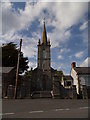
Grange Church
St Aidan's Church on the Salter's Grange Road at Grange.
Image: © Robert Ashby
Taken: 4 Sep 2013
0.19 miles
2
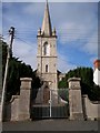
The Grange Parish Church, Loughgall
The church at Grange was built in 1773 as a chapel-of-ease to Armagh at the expense of Archbishop Richard Robinson and designed by his architect Thomas Cooley. It was erected in white stone (limestone) which was taken from a quarry about half a mile away. Its tall spire provides an eye-catching view from the Primate's demesne in Armagh. The transepts, added at the same time as the chancel in 1843, detract slightly from the facade as they project two blank walls out at the sides of the church. The church was not actually consecrated until 1782.
Image: © P Flannagan
Taken: 10 Oct 2007
0.22 miles
3
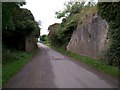
Remains of an old Railway Bridge, Ballybrannon Road, Armagh
This railway bridge probably carried the, now abandoned, railway line from Portadown to Armagh.
Image: © P Flannagan
Taken: 10 Oct 2007
0.24 miles