IMAGES TAKEN NEAR TO
Loughgall Road, ARMAGH, BT61 7PR
Introduction
This page details the photographs taken nearby to Loughgall Road, BT61 7PR by members of the Geograph project.
The Geograph project started in 2005 with the aim of publishing, organising and preserving representative images for every square kilometre of Great Britain, Ireland and the Isle of Man.

There are currently over 7.5m images from over14,400 individuals and you can help contribute to the project by visiting https://www.geograph.org.uk
Image Map
Images are licensed for reuse under creativecommons.org/licenses/by-sa/2.0
Notes
- Clicking on the map will re-center to the selected point.
- The higher the marker number, the further away the image location is from the centre of the postcode.
Image Listing (8 Images Found)
Images are licensed for reuse under creativecommons.org/licenses/by-sa/2.0
Image
Details
Distance
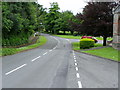
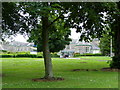
1
St. Lukes Hospital grounds
At the junction with Mullinure Lane
Image: © HENRY CLARK
Taken: 7 Jul 2009
0.05 miles
2
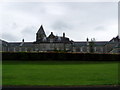
The Hill Building
In the grounds of St. Lukes Hospital, Armagh
Image: © HENRY CLARK
Taken: 7 Jul 2009
0.06 miles
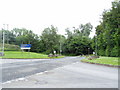
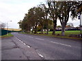
3
Mullinure Lane, Armagh
The photograph was taken in the centre of a large Health Service Complex comprising many facilities for health care. The building in the background is the original St. Luke's Hospital, Armagh.
Image: © P Flannagan
Taken: 10 Oct 2007
0.07 miles
4
St. Lukes Hospital grounds
The Hill Building
Image: © HENRY CLARK
Taken: 7 Jul 2009
0.08 miles
6
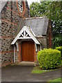
Church at St. Lukes Hospital, Armagh
Closeup of doorway Image
Image: © HENRY CLARK
Taken: 7 Jul 2009
0.20 miles
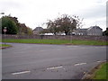
7
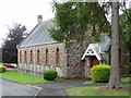
St. Lukes Hospital grounds
A small church in the grounds
Image: © HENRY CLARK
Taken: 7 Jul 2009
0.22 miles