IMAGES TAKEN NEAR TO
Banbrook Hill, ARMAGH, BT61 7LP
Introduction
This page details the photographs taken nearby to Banbrook Hill, BT61 7LP by members of the Geograph project.
The Geograph project started in 2005 with the aim of publishing, organising and preserving representative images for every square kilometre of Great Britain, Ireland and the Isle of Man.

There are currently over 7.5m images from over14,400 individuals and you can help contribute to the project by visiting https://www.geograph.org.uk
Image Map
Images are licensed for reuse under creativecommons.org/licenses/by-sa/2.0
Notes
- Clicking on the map will re-center to the selected point.
- The higher the marker number, the further away the image location is from the centre of the postcode.
Image Listing (93 Images Found)
Images are licensed for reuse under creativecommons.org/licenses/by-sa/2.0
Image
Details
Distance
1
Republican mural, Banbrook Hill
The far flag is the 'Starry Plough' which was popularised during the 1916 War of Independence. The closest one is the Irish tricolour. Above the flags are the portraits of the 1981 Hunger Strikers.
Image: © Dean Molyneaux
Taken: 24 Jul 2009
0.05 miles
2
Railway Street, Armagh
Along Railway Street looking towards the city centre and Lonsdale Road.
Image: © Dean Molyneaux
Taken: 24 Jul 2009
0.09 miles
4
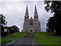
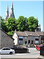
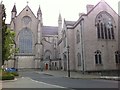
St. Patrick's Cathedral (R.C.), Armagh
On Cathedral Road - seat of the Armagh Diocese.
Image: © Dean Molyneaux
Taken: 24 Jul 2009
0.11 miles
5
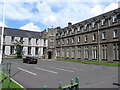
St Patrick's Grammar School, Armagh
This former boarding school stands next to the Catholic Cathedral.
http://www.stpatricksarmagh.org/about/
Image: © Eric Jones
Taken: 2 Aug 2012
0.11 miles
7
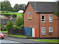
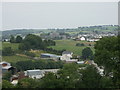
Modern housing in Brookhill Crescent
The houses stand below St Patrick's Catholic Cathedral,
Image: © Eric Jones
Taken: 1 Jun 2016
0.12 miles
8
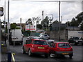
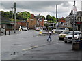
Loughgall Road, Armagh
The Loughgall Road in Armagh - the old G.N.R. (I) railway station was where the 'Ulsterbus' sign (extreme right) is today. Interestingly, Armagh was one of the first towns in Ireland to be served by rail in 1848 - and also one of the first to lose its services in 1957.
Image: © Dean Molyneaux
Taken: 24 Jul 2009
0.13 miles
10
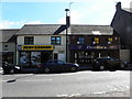
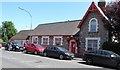
Sean Graham / Sean Devlin's Bar, Armagh
They are located at Lower English Street
Image: © Kenneth Allen
Taken: 18 Jun 2014
0.14 miles