IMAGES TAKEN NEAR TO
Chesterfield Park, BELFAST, BT6 0HQ
Introduction
This page details the photographs taken nearby to Chesterfield Park, BT6 0HQ by members of the Geograph project.
The Geograph project started in 2005 with the aim of publishing, organising and preserving representative images for every square kilometre of Great Britain, Ireland and the Isle of Man.

There are currently over 7.5m images from over14,400 individuals and you can help contribute to the project by visiting https://www.geograph.org.uk
Image Map
Images are licensed for reuse under creativecommons.org/licenses/by-sa/2.0
Notes
- Clicking on the map will re-center to the selected point.
- The higher the marker number, the further away the image location is from the centre of the postcode.
Image Listing (72 Images Found)
Images are licensed for reuse under creativecommons.org/licenses/by-sa/2.0
Image
Details
Distance
1
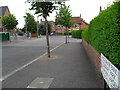
Cheltenham Park, Rosetta
Cheltenham Park in Belfast's Rosetta area. Seen here as continuation of Knockbreda Road.
Image: © Dean Molyneaux
Taken: 9 Jul 2009
0.04 miles
2
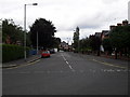
Knockbreda Road, Rosetta
Part of the Knockbreda Road, looking towards Rosetta.
Image: © Dean Molyneaux
Taken: 9 Jul 2009
0.06 miles
3
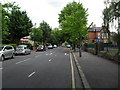
Knockbreda Road, Ormeau
Knockbreda Road links Rosetta with the Upper Ormeau.
Image: © Dean Molyneaux
Taken: 9 Jul 2009
0.07 miles
4
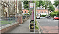
Bus stop, Knockbreda Road, Belfast (June 2016)
A bus stop at the Ormeau Road end of the Knockbreda Road Image Off the main Metro routes, the service is infrequent.
Image: © Albert Bridge
Taken: 23 Jun 2016
0.09 miles
5
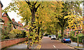
Rosetta Park, Belfast
A street of redbrick late-Victorian suburban houses running between the Ormeau and Ravenhill Roads. Greatly enhanced today by the colours of autumn.
Image: © Albert Bridge
Taken: 19 Oct 2012
0.11 miles
6
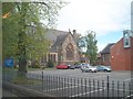
Knockbreda Presbyterian Church, Ormeau Road
Image: © Eric Jones
Taken: 27 Apr 2012
0.12 miles
7
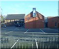
The car park of Newtownbreda Presbyterian Church
The school buildings in the background are in square J3571
Image: © Eric Jones
Taken: 7 Dec 2018
0.12 miles
8
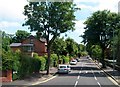
Leafy suburbs - Knockbreda Road, South Belfast
Image: © Eric Jones
Taken: 10 Jul 2015
0.12 miles
9
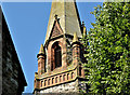
Spire (part), St John's Presbyterian church, Newtownbreda, Belfast (July 2017)
See Image (April 2012) and Image (November 2005). A back view on a gloriously sunny summer day. The church was completed in 1892 to a design by Vincent Craig.
Image: © Albert Bridge
Taken: 17 Jul 2017
0.12 miles
10
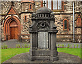
War memorial, Newtownbreda Presbyterian church, Belfast
First World War memorial, at Newtownbreda (St John’s) Presbyterian church Image, facing the Ormeau Road.
Image: © Albert Bridge
Taken: 20 Jul 2011
0.13 miles