IMAGES TAKEN NEAR TO
Knockbreda Drive, BELFAST, BT6 0HJ
Introduction
This page details the photographs taken nearby to Knockbreda Drive, BT6 0HJ by members of the Geograph project.
The Geograph project started in 2005 with the aim of publishing, organising and preserving representative images for every square kilometre of Great Britain, Ireland and the Isle of Man.

There are currently over 7.5m images from over14,400 individuals and you can help contribute to the project by visiting https://www.geograph.org.uk
Image Map
Images are licensed for reuse under creativecommons.org/licenses/by-sa/2.0
Notes
- Clicking on the map will re-center to the selected point.
- The higher the marker number, the further away the image location is from the centre of the postcode.
Image Listing (57 Images Found)
Images are licensed for reuse under creativecommons.org/licenses/by-sa/2.0
Image
Details
Distance

5
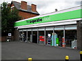
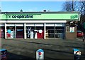
Co-op, Ormeau Road
Co-Op on the Upper Ormeau.
Image: © Dean Molyneaux
Taken: 9 Jul 2009
0.13 miles
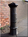
7
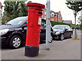
Pillar box, Belfast
A leaning GR pillar box, on the Ormeau Road, close to Knockbreda Park
Image: © Albert Bridge
Taken: 20 Jul 2011
0.14 miles
8
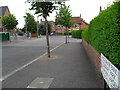
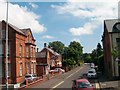
Cheltenham Park, Rosetta
Cheltenham Park in Belfast's Rosetta area. Seen here as continuation of Knockbreda Road.
Image: © Dean Molyneaux
Taken: 9 Jul 2009
0.14 miles
9
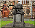
War memorial, Newtownbreda Presbyterian church, Belfast
First World War memorial, at Newtownbreda (St John’s) Presbyterian church Image, facing the Ormeau Road.
Image: © Albert Bridge
Taken: 20 Jul 2011
0.15 miles
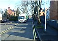
10
Boundary Post, Belfast
Old parliamentary boundary post on the Saintfield Road in Belfast.
The inscription reads
"Parliamentary
and Municipal Boundary of
Belfast
Ormeau Division
Ormeau Ward
1918".
Image: © Rossographer
Taken: 28 Feb 2011
0.15 miles