IMAGES TAKEN NEAR TO
Coolkill Road, ARMAGH, BT60 4RB
Introduction
This page details the photographs taken nearby to Coolkill Road, BT60 4RB by members of the Geograph project.
The Geograph project started in 2005 with the aim of publishing, organising and preserving representative images for every square kilometre of Great Britain, Ireland and the Isle of Man.

There are currently over 7.5m images from over14,400 individuals and you can help contribute to the project by visiting https://www.geograph.org.uk
Image Map
Images are licensed for reuse under creativecommons.org/licenses/by-sa/2.0
Notes
- Clicking on the map will re-center to the selected point.
- The higher the marker number, the further away the image location is from the centre of the postcode.
Image Listing (3 Images Found)
Images are licensed for reuse under creativecommons.org/licenses/by-sa/2.0
Image
Details
Distance
1
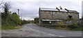
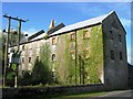
Marrassitt or College Hall Townland
This old mill is along the roadside.
Image: © Kenneth Allen
Taken: 7 Nov 2007
0.03 miles
3
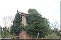
Tynan Signal Cabin
Tynan, Co. Armagh, was on the GNR line from Armagh to Clones, via Monaghan. It closed in 1957 as part of the ''Great Closure'', and was the Northern customs station for that line, its southern counterpart being a few miles down the line at Glaslough. Most of the buildings still stand today, albeit in a derelict condition. The signal cabin seen here is of typical GNR design.
Image: © N-a
Taken: 6 Apr 2014
0.19 miles