IMAGES TAKEN NEAR TO
Old Forge, ARMAGH, BT60 4LP
Introduction
This page details the photographs taken nearby to Old Forge, BT60 4LP by members of the Geograph project.
The Geograph project started in 2005 with the aim of publishing, organising and preserving representative images for every square kilometre of Great Britain, Ireland and the Isle of Man.

There are currently over 7.5m images from over14,400 individuals and you can help contribute to the project by visiting https://www.geograph.org.uk
Image Map
Images are licensed for reuse under creativecommons.org/licenses/by-sa/2.0
Notes
- Clicking on the map will re-center to the selected point.
- The higher the marker number, the further away the image location is from the centre of the postcode.
Image Listing (18 Images Found)
Images are licensed for reuse under creativecommons.org/licenses/by-sa/2.0
Image
Details
Distance
1
Digby's Restaurant, Killylea
It is located at Main Street
Image: © Kenneth Allen
Taken: 9 Jul 2012
0.02 miles
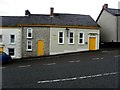
2

Digby's Bar, Killylea
It is located at Main Street
Image: © Kenneth Allen
Taken: 9 Jul 2012
0.03 miles
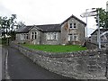

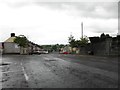
5
St Mark's Church hall, Killylea
It is located along Main Street
Image: © Kenneth Allen
Taken: 9 Jul 2012
0.05 miles
6
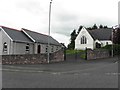
Church buildings, Killylea
Looking NNE
Image: © Kenneth Allen
Taken: 9 Jul 2012
0.05 miles
7
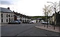
Killylea, County Armagh
It is located between Armagh and Caledon.
Image: © Kenneth Allen
Taken: 7 Nov 2007
0.06 miles
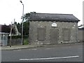
8
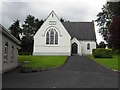
Methodist Church, Killylea
Pictured along Main Street
Image: © Kenneth Allen
Taken: 9 Jul 2012
0.06 miles
10
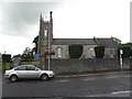
St Mark's Church of Ireland
Looking north
Image: © Kenneth Allen
Taken: 9 Jul 2012
0.07 miles