IMAGES TAKEN NEAR TO
Church Street, ARMAGH, BT60 4HZ
Introduction
This page details the photographs taken nearby to Church Street, BT60 4HZ by members of the Geograph project.
The Geograph project started in 2005 with the aim of publishing, organising and preserving representative images for every square kilometre of Great Britain, Ireland and the Isle of Man.

There are currently over 7.5m images from over14,400 individuals and you can help contribute to the project by visiting https://www.geograph.org.uk
Image Map
Images are licensed for reuse under creativecommons.org/licenses/by-sa/2.0
Notes
- Clicking on the map will re-center to the selected point.
- The higher the marker number, the further away the image location is from the centre of the postcode.
Image Listing (34 Images Found)
Images are licensed for reuse under creativecommons.org/licenses/by-sa/2.0
Image
Details
Distance
1
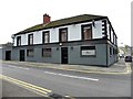
Hughes Bar, Middletown
Pictured on the Main Street
Image: © Kenneth Allen
Taken: 22 Oct 2012
0.05 miles
2
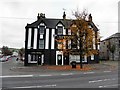
Lennons, Middleton
Pictured along Main Street - a change in colour since I pictured it last in November, 2007 Image]
Image: © Kenneth Allen
Taken: 22 Oct 2012
0.08 miles
3
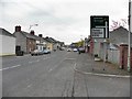
Middletown, County Armagh
Heading ENE
Image: © Kenneth Allen
Taken: 22 Oct 2012
0.08 miles
4
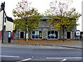
Former Market House, Middleton
Pictured along Main Street
Brian McElernon has it featured in his website here http://irishantiquities.bravehost.com/armagh/middletown/middletownMH.html
Image: © Kenneth Allen
Taken: 22 Oct 2012
0.08 miles
5
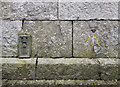
Bench Marks, Middletown
Two bench marks on the front of the old Middletown Market House Image
On the left is a flush bracket, numbered OSBM 3193.
It has been levelled to 43.44 metres above MSL.
On the right is an old bolt mark - it consists of a cut mark with a copper bolt driven into the front wall and dates from the 1st geodetic levelling of Ireland which took place in 1839-43. It is the 70th mark in a line stretching from Newtownbutler to Belfast (ending at Image) which passed through Clones, Monaghan, Armagh, Lurgan and Lisburn. The original remarks describe it as a "Copper bolt driven into the wall of Middletown Market House; 3.5 feet above centre of road" and it was originally levelled to 151.777 feet above sea level.
Image: © Rossographer
Taken: 18 Feb 2016
0.08 miles
6
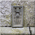
Flush Bracket, Middletown
Flush bracket bench mark on the front of the old Middletown Market House Image
The number on the bracket is OSBM 3193.
The mark has been levelled to 43.44 metres above MSL.
Image: © Rossographer
Taken: 18 Feb 2016
0.08 miles
7
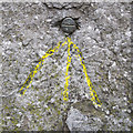
Bench Mark, Middletown
Bench mark on the front of the old Middletown Market House Image
It consists of a cut mark with a copper bolt driven into the front wall and dates from the 1st geodetic levelling of Ireland which took place in 1839-43. It is the 70th mark in a line stretching from Newtownbutler to Belfast (ending at Image) which passed through Clones, Monaghan, Armagh, Lurgan and Lisburn. The original remarks describe it as a "Copper bolt driven into the wall of Middletown Market House; 3.5 feet above centre of road" and it was originally levelled to 151.777 feet above sea level.
Image: © Rossographer
Taken: 18 Feb 2016
0.08 miles
8
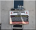
Middletown GAA banner on Main Street
This is hung on the face of a derelict house.
Image]
Image: © Eric Jones
Taken: 2 Jun 2016
0.08 miles
9
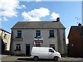
Derelict house on Main Street in Middletown
The banner refers to the local GAA club.
Image]
Image: © Eric Jones
Taken: 2 Jun 2016
0.08 miles
10
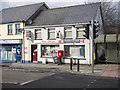
Middletown Post Office
The Post Office in Middletown, Armagh. The postbox can be seen in detail at Image
Image: © Rossographer
Taken: 18 Feb 2016
0.08 miles