IMAGES TAKEN NEAR TO
Monaghan Road, ARMAGH, BT60 4EF
Introduction
This page details the photographs taken nearby to Monaghan Road, BT60 4EF by members of the Geograph project.
The Geograph project started in 2005 with the aim of publishing, organising and preserving representative images for every square kilometre of Great Britain, Ireland and the Isle of Man.

There are currently over 7.5m images from over14,400 individuals and you can help contribute to the project by visiting https://www.geograph.org.uk
Image Map
Images are licensed for reuse under creativecommons.org/licenses/by-sa/2.0
Notes
- Clicking on the map will re-center to the selected point.
- The higher the marker number, the further away the image location is from the centre of the postcode.
Image Listing (8 Images Found)
Images are licensed for reuse under creativecommons.org/licenses/by-sa/2.0
Image
Details
Distance
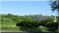
1
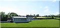
Neighbouring farmhouses on the west side of the A3
Image: © Eric Jones
Taken: 2 Jun 2016
0.11 miles
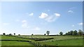
2
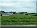
Drumlin-side dairy farm north-east of Middletown
The image was taken from the A3.
Image: © Eric Jones
Taken: 4 Jun 2016
0.14 miles
4
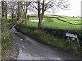
Farnaloy Road
A narrow country road and muddy too!
Image: © Kenneth Allen
Taken: 21 Nov 2007
0.20 miles
5
Monaghan Road near Farnaloy
Heading south-west
Image: © Kenneth Allen
Taken: 21 Nov 2007
0.20 miles
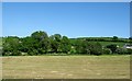
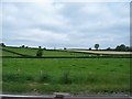
7
Hay field west of the A3 (Monaghan Road) is Brootally TD
Image: © Eric Jones
Taken: 2 Jun 2016
0.21 miles
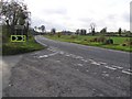
8
Farnaloy Road at its junction with the A3
Image: © Eric Jones
Taken: 2 Jun 2016
0.24 miles