IMAGES TAKEN NEAR TO
Umgola Manor, ARMAGH, BT60 4BF
Introduction
This page details the photographs taken nearby to Umgola Manor, BT60 4BF by members of the Geograph project.
The Geograph project started in 2005 with the aim of publishing, organising and preserving representative images for every square kilometre of Great Britain, Ireland and the Isle of Man.

There are currently over 7.5m images from over14,400 individuals and you can help contribute to the project by visiting https://www.geograph.org.uk
Image Map
Images are licensed for reuse under creativecommons.org/licenses/by-sa/2.0
Notes
- Clicking on the map will re-center to the selected point.
- The higher the marker number, the further away the image location is from the centre of the postcode.
Image Listing (4 Images Found)
Images are licensed for reuse under creativecommons.org/licenses/by-sa/2.0
Image
Details
Distance
1
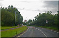
Entering the Armagh outskirts along Killylea Road
This view is from the western approach to Armagh on the A28 Road; photographer is above the roadway surface atop the eastbound travel lane. The time is about seven o'clock pm.
Image: © C Michael Hogan
Taken: 14 Jul 2011
0.15 miles
2
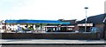
Topaz Filling Station on the corner of Nursery Road and Killylea Road
Image: © Eric Jones
Taken: 1 Jun 2016
0.23 miles
3
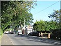
View south-eastwards along Nursery Road, Armagh
Image: © Eric Jones
Taken: 1 Jun 2016
0.24 miles
4
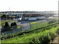
Club House and Ground at Pearse ?g Park, Ballycrummy
Since 2007, the Pearse Óg GAA Club which was formed in the 1950s, has developed this site on the western outskirts of Armagh building a new stadium and a clubhouse. The ground is known in Irish as Pearse Óg Parkhis.
http://www.pearseoggfc.com/index.php/club-information/club-history
Image: © Eric Jones
Taken: 1 Jun 2016
0.24 miles