IMAGES TAKEN NEAR TO
Keady Road, ARMAGH, BT60 4AB
Introduction
This page details the photographs taken nearby to Keady Road, BT60 4AB by members of the Geograph project.
The Geograph project started in 2005 with the aim of publishing, organising and preserving representative images for every square kilometre of Great Britain, Ireland and the Isle of Man.

There are currently over 7.5m images from over14,400 individuals and you can help contribute to the project by visiting https://www.geograph.org.uk
Image Map
Images are licensed for reuse under creativecommons.org/licenses/by-sa/2.0
Notes
- Clicking on the map will re-center to the selected point.
- The higher the marker number, the further away the image location is from the centre of the postcode.
Image Listing (31 Images Found)
Images are licensed for reuse under creativecommons.org/licenses/by-sa/2.0
Image
Details
Distance
2
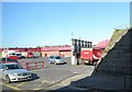
McAnerney's Supermarket on Irish Street
This image was taken from the Friary Road viaduct. The supermarket is located on Irish Street.
Image: © Eric Jones
Taken: 1 Jun 2016
0.08 miles
3
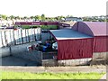
Club House and Ground at Pearse ?g Park, Ballycrummy
Since 2007, the Pearse Óg GAA Club which was formed in the 1950s, has developed this site on the western outskirts of Armagh building a new stadium and a clubhouse. The ground is known in Irish as Pearse Óg Parkhis.
http://www.pearseoggfc.com/index.php/club-information/club-history
Image: © Eric Jones
Taken: 1 Jun 2016
0.12 miles
4
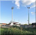
Grandstand at the Pearce ?g GAA Club, Armagh
Since 2007, the Pearse Óg GAA Club which was formed in the 1950s, has developed this site on the western outskirts of Armagh building a new stadium and a clubhouse. The ground is known in Irish as Pearse Óg Parkhis.
http://www.pearseoggfc.com/index.php/club-information/club-history
Image: © Eric Jones
Taken: 1 Jun 2016
0.12 miles
5
Bridge carrying Friary Road, Armagh over the A3 (Irish Street)
Image: © Eric Jones
Taken: 2 Jun 2016
0.14 miles
6
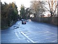
Irish Street, Armagh
The southern end of Irish Street at its junction with the Monaghan Road.
Image: © Dean Molyneaux
Taken: 27 Dec 2009
0.14 miles
7
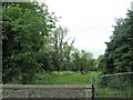
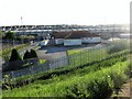
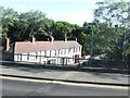
Development land in the south-western suburbs of Armagh City
Image: © Eric Jones
Taken: 4 Jun 2016
0.14 miles
8
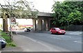
Viaduct carrying the A28 over Irish Street
Image: © Eric Jones
Taken: 1 Jun 2016
0.14 miles
9
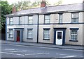
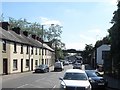
Terrace of houses in Irish Street
These are located below the viaduct which carries the A28.
Image: © Eric Jones
Taken: 1 Jun 2016
0.15 miles
10
Houses below the viaduct crossing Irish Street
The image was taken from the A3 (Friary Road) viaduct.
Image: © Eric Jones
Taken: 2 Jun 2016
0.15 miles