IMAGES TAKEN NEAR TO
Derrynoose Road, ARMAGH, BT60 3QR
Introduction
This page details the photographs taken nearby to Derrynoose Road, BT60 3QR by members of the Geograph project.
The Geograph project started in 2005 with the aim of publishing, organising and preserving representative images for every square kilometre of Great Britain, Ireland and the Isle of Man.

There are currently over 7.5m images from over14,400 individuals and you can help contribute to the project by visiting https://www.geograph.org.uk
Image Map
Images are licensed for reuse under creativecommons.org/licenses/by-sa/2.0
Notes
- Clicking on the map will re-center to the selected point.
- The higher the marker number, the further away the image location is from the centre of the postcode.
Image Listing (4 Images Found)
Images are licensed for reuse under creativecommons.org/licenses/by-sa/2.0
Image
Details
Distance
1
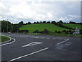
Castleblayney Road, Clay
At the junction with the Derrynoose Road in Clay townland - one mile southwest of Keady.
Image: © Dean Molyneaux
Taken: 19 Jul 2009
0.04 miles
2
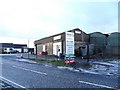
Burke's Tyres & Exhausts, Keady
On the Castleblayney Road in townland of Lagan.
Image: © Dean Molyneaux
Taken: 27 Dec 2009
0.14 miles
3
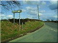
Derrynoose Road, Clay
Where the Lagan Road meets the B3 Derrynoose Road in the Townland of Clay.
Image: © Dean Molyneaux
Taken: 21 Mar 2010
0.19 miles
4
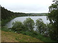
Clay Lake
Looking east from the B32 between Keady and the border in south Armagh.
Image: © Jonathan Billinger
Taken: 17 May 2007
0.22 miles