IMAGES TAKEN NEAR TO
Maddan Road, ARMAGH, BT60 3LJ
Introduction
This page details the photographs taken nearby to Maddan Road, BT60 3LJ by members of the Geograph project.
The Geograph project started in 2005 with the aim of publishing, organising and preserving representative images for every square kilometre of Great Britain, Ireland and the Isle of Man.

There are currently over 7.5m images from over14,400 individuals and you can help contribute to the project by visiting https://www.geograph.org.uk
Image Map
Images are licensed for reuse under creativecommons.org/licenses/by-sa/2.0
Notes
- Clicking on the map will re-center to the selected point.
- The higher the marker number, the further away the image location is from the centre of the postcode.
Image Listing (6 Images Found)
Images are licensed for reuse under creativecommons.org/licenses/by-sa/2.0
Image
Details
Distance
1
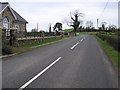
Road at Drummond
Heading north north-west
Image: © Kenneth Allen
Taken: 28 Jan 2008
0.09 miles
2
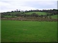
Countryside near Drummond
Looking eastwards
Image: © Kenneth Allen
Taken: 28 Jan 2008
0.11 miles
4
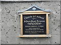
Church Information Board, Madden Church of Ireland
Pictured here Image]
Image: © Kenneth Allen
Taken: 28 Aug 2013
0.24 miles
5
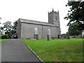
Madden Church of Ireland, St John's Parish, Derrynoose
It is located along Farmaloy Road
See close-up of board here Image]
Image: © Kenneth Allen
Taken: 28 Aug 2013
0.24 miles
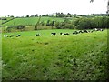
6
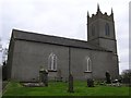
Madden Church of Ireland
It is in the parish of Derrynose
Image: © Kenneth Allen
Taken: 28 Jan 2008
0.25 miles