IMAGES TAKEN NEAR TO
Old Mill Avenue, ARMAGH, BT60 3JF
Introduction
This page details the photographs taken nearby to Old Mill Avenue, BT60 3JF by members of the Geograph project.
The Geograph project started in 2005 with the aim of publishing, organising and preserving representative images for every square kilometre of Great Britain, Ireland and the Isle of Man.

There are currently over 7.5m images from over14,400 individuals and you can help contribute to the project by visiting https://www.geograph.org.uk
Image Map
Images are licensed for reuse under creativecommons.org/licenses/by-sa/2.0
Notes
- Clicking on the map will re-center to the selected point.
- The higher the marker number, the further away the image location is from the centre of the postcode.
Image Listing (4 Images Found)
Images are licensed for reuse under creativecommons.org/licenses/by-sa/2.0
Image
Details
Distance
1
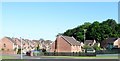
New housing estate on the south-western outskirts of Milford
New housing estates have been built on the outskirts of the former mill village of Milford to house commuters who work in the City of Armagh.
Image: © Eric Jones
Taken: 2 Jun 2016
0.22 miles
2

Flush Bracket, Milford
Flush bracket bench mark on Milford Orange Hall Image
The number on the bracket is OSBM 3191.
The mark is in a line between the fundamental bench marks at Armagh and Newtownbutler; it has been levelled to 46.91 metres above MSL.
Image: © Rossographer
Taken: 29 Jul 2016
0.23 miles
3
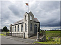
Milford Orange Hall
Orange Lodge in Milford, County Armagh, dating from 1911. It is the home of Milford Temperance And Benefit L.O.L. No.353.
Image: © Rossographer
Taken: 29 Jul 2016
0.24 miles
4
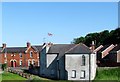
The rear of the Milford Orange Hall, Milford
The image was taken from the A3 (Monaghan Road).
Image: © Eric Jones
Taken: 2 Jun 2016
0.25 miles