IMAGES TAKEN NEAR TO
Castleblayney Road, ARMAGH, BT60 3HY
Introduction
This page details the photographs taken nearby to Castleblayney Road, BT60 3HY by members of the Geograph project.
The Geograph project started in 2005 with the aim of publishing, organising and preserving representative images for every square kilometre of Great Britain, Ireland and the Isle of Man.

There are currently over 7.5m images from over14,400 individuals and you can help contribute to the project by visiting https://www.geograph.org.uk
Image Map
Images are licensed for reuse under creativecommons.org/licenses/by-sa/2.0
Notes
- Clicking on the map will re-center to the selected point.
- The higher the marker number, the further away the image location is from the centre of the postcode.
Image Listing (6 Images Found)
Images are licensed for reuse under creativecommons.org/licenses/by-sa/2.0
Image
Details
Distance
1
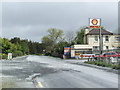
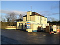
Filling station on the border
South Armagh begins just beyond the building.
Image: © Jonathan Billinger
Taken: 17 May 2007
0.10 miles
2
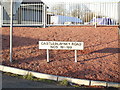
Sign at Carrickduff
A few hundred yard north of the border - in the townland of Carrickduff, County Armagh.
Image: © Dean Molyneaux
Taken: 27 Dec 2009
0.14 miles
3
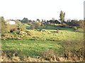
Carrickduff Townland
County Armagh (off the Castleblayney Road at Carnagh)
Image: © Dean Molyneaux
Taken: 27 Dec 2009
0.17 miles
4
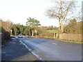
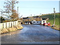
The Border at Tullynagrow
Looking into Northern Ireland (UK).
Image: © Dean Molyneaux
Taken: 27 Dec 2009
0.19 miles
5
Fuel depot, Tullynagrow
One of about five similar depots, which are very common around the NI/RoI border.
Image: © Dean Molyneaux
Taken: 27 Dec 2009
0.23 miles
6
Former Customs Station, Tullynagrow
Just on the County Monaghan side of the border, a remnant of the days before the creation of the "Common Travel Area" - customs checks were commonplace until 1993.
Image: © Dean Molyneaux
Taken: 27 Dec 2009
0.24 miles