IMAGES TAKEN NEAR TO
Castleblayney Road, ARMAGH, BT60 3HS
Introduction
This page details the photographs taken nearby to Castleblayney Road, BT60 3HS by members of the Geograph project.
The Geograph project started in 2005 with the aim of publishing, organising and preserving representative images for every square kilometre of Great Britain, Ireland and the Isle of Man.

There are currently over 7.5m images from over14,400 individuals and you can help contribute to the project by visiting https://www.geograph.org.uk
Image Map
Images are licensed for reuse under creativecommons.org/licenses/by-sa/2.0
Notes
- Clicking on the map will re-center to the selected point.
- The higher the marker number, the further away the image location is from the centre of the postcode.
Image Listing (6 Images Found)
Images are licensed for reuse under creativecommons.org/licenses/by-sa/2.0
Image
Details
Distance
1
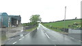
Barns next to Castleblaney Road
Two miles south of Keady, looking north along a wet road, just after a thunderstorm.
Image: © Sean Davis
Taken: 5 Jun 2020
0.04 miles
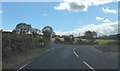
2
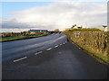
Castleblayney Road at Kilcam
At the junction with the Tievenamara Road. Kilcam Townland.
Image: © Dean Molyneaux
Taken: 27 Dec 2009
0.07 miles
3
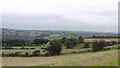
Clay Townland
View over Clay Townland from Carryoghill. This is on the route of the Keady Hills, Lakes, Rivers and Mills Walk. See https://sites.google.com/view/keadywalk/home
Image: © Sean Davis
Taken: 29 Aug 2021
0.08 miles
4
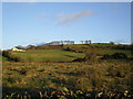
Kilcam Townland
Off the Castleblayney Road. Clay Townland begins at the foot of the hill.
Image: © Dean Molyneaux
Taken: 27 Dec 2009
0.10 miles
5
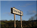
Sign at Kilcam
I've seen their lorries out and about... On the Castleblayney Road in the townland of Kilcam.
Image: © Dean Molyneaux
Taken: 27 Dec 2009
0.11 miles
6
Junction of Castleblaney Road and Tievenamara Road
Image: © Sean Davis
Taken: 5 Jun 2020
0.13 miles