IMAGES TAKEN NEAR TO
Fergort Road, ARMAGH, BT60 3EX
Introduction
This page details the photographs taken nearby to Fergort Road, BT60 3EX by members of the Geograph project.
The Geograph project started in 2005 with the aim of publishing, organising and preserving representative images for every square kilometre of Great Britain, Ireland and the Isle of Man.

There are currently over 7.5m images from over14,400 individuals and you can help contribute to the project by visiting https://www.geograph.org.uk
Image Map
Images are licensed for reuse under creativecommons.org/licenses/by-sa/2.0
Notes
- Clicking on the map will re-center to the selected point.
- The higher the marker number, the further away the image location is from the centre of the postcode.
Image Listing (4 Images Found)
Images are licensed for reuse under creativecommons.org/licenses/by-sa/2.0
Image
Details
Distance
1
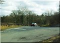
Fergort Road at Crossnamoyle
At the junction with the Drumhillery Road.
Townland of Crossnamoyle.
Image: © Dean Molyneaux
Taken: 21 Mar 2010
0.06 miles
2
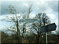
Finger post at Crossnamoyle
The elusive 'C Road' numbers (normally used for administrative purposes only) are quite evident around this part of South Armagh.
Here the C193 Drumhillery Road leads north from the Fergort Road (Derrynoose) towards Middletown and Caledon.
Townland of Crossnamoyle.
Image: © Dean Molyneaux
Taken: 21 Mar 2010
0.07 miles
3

Derrynoose Road at Crossnamoyle
Townland of Crossnamoyle.
Image: © Dean Molyneaux
Taken: 27 Dec 2009
0.19 miles
4
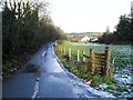
Drumnahevil Road, Crossnamoyle
East of Derrynoose village - Townland of Crossnamoyle, County Armagh.
Image: © Dean Molyneaux
Taken: 27 Dec 2009
0.24 miles