IMAGES TAKEN NEAR TO
Keady Road, ARMAGH, BT60 3EW
Introduction
This page details the photographs taken nearby to Keady Road, BT60 3EW by members of the Geograph project.
The Geograph project started in 2005 with the aim of publishing, organising and preserving representative images for every square kilometre of Great Britain, Ireland and the Isle of Man.

There are currently over 7.5m images from over14,400 individuals and you can help contribute to the project by visiting https://www.geograph.org.uk
Image Map
Images are licensed for reuse under creativecommons.org/licenses/by-sa/2.0
Notes
- Clicking on the map will re-center to the selected point.
- The higher the marker number, the further away the image location is from the centre of the postcode.
Image Listing (19 Images Found)
Images are licensed for reuse under creativecommons.org/licenses/by-sa/2.0
Image
Details
Distance
1
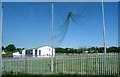
Keady GAA Gerard McGleenan Memorial Park
These GAA grounds are located on the northern outskirts of Keady. They are named after a young GAA player who was killed in a Glenanne Gang car bomb attack on The Step Inn at Keady.
https://en.wikipedia.org/wiki/Glenanne_gang
Image: © Eric Jones
Taken: 2 Jun 2016
0.03 miles
2
Keady GAA Grounds
The pitch at Keady GAA Gerard McGleenan Memorial Park. The entrance to the park is on Armagh Road. Photo is taken from Crossmore Road.
Image: © Sean Davis
Taken: 1 Mar 2020
0.12 miles
3
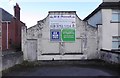
The Wee Shop
During the 1970s and 1980s locals knew this as "The Wee Shop" on Armagh Road, Keady. At the time it was the only shop at this end of the town. Sadly, it's been closed for some time now.
Image: © Sean Davis
Taken: 4 Mar 2020
0.13 miles
5
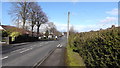
Armagh Road, Keady
Looking north along Armagh Road in Keady.
Image: © Sean Davis
Taken: 1 Mar 2020
0.15 miles
6
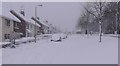
Armagh Road 2018 Snow
Armagh Road, Keady. This was "The Beast From The East" taken 1st March 2018
Image: © Sean Davis
Taken: 1 Mar 2018
0.19 miles
7
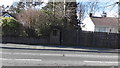
Who Stole the Post Box
The pillar, on Armagh Road, Keady, was home to a red Royal Mail post box for decades. Now it just contains a big empty hole.
Image: © Sean Davis
Taken: 1 Mar 2020
0.19 miles
8
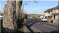
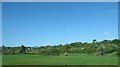
Tassagh Road
Looking along Tassagh Road as it exits Keady. Taken from the bottom of "The Black Pad".
Image: © Sean Davis
Taken: 22 Mar 2020
0.20 miles
9
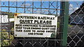
Old Southern Railway Sign
Very old Southern Railway sign on the gates to "The Furniture Restorer" on Tassagh Road, Keady. The railway at Keady opened in 1909 and closed in 1957.
Image: © Sean Davis
Taken: 4 Mar 2020
0.21 miles
10
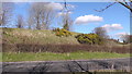
Old Railway Embankment
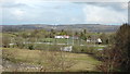
Old railway embankment beside Tassagh Road, Keady. This is on the Keady to Armagh railway. The line opened in 1909 and closed in 1957. See https://en.wikipedia.org/wiki/Castleblayney,_Keady_and_Armagh_Railway
Image: © Sean Davis
Taken: 4 Mar 2020
0.21 miles