IMAGES TAKEN NEAR TO
Mulcreevy Crescent, ARMAGH, BT60 3BH
Introduction
This page details the photographs taken nearby to Mulcreevy Crescent, BT60 3BH by members of the Geograph project.
The Geograph project started in 2005 with the aim of publishing, organising and preserving representative images for every square kilometre of Great Britain, Ireland and the Isle of Man.

There are currently over 7.5m images from over14,400 individuals and you can help contribute to the project by visiting https://www.geograph.org.uk
Image Map
Images are licensed for reuse under creativecommons.org/licenses/by-sa/2.0
Notes
- Clicking on the map will re-center to the selected point.
- The higher the marker number, the further away the image location is from the centre of the postcode.
Image Listing (4 Images Found)
Images are licensed for reuse under creativecommons.org/licenses/by-sa/2.0
Image
Details
Distance
1
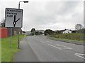
Victoria Street, Keady
Heading SSE towards Darkley
Image: © Kenneth Allen
Taken: 22 Oct 2012
0.12 miles
2
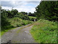
Laneway, Cargaclogher
Laneway in the townland of Cargaclogher - half a mile south of Keady village.
Image: © Dean Molyneaux
Taken: 19 Jul 2009
0.23 miles
3
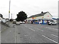
McGrane's Supermarket, Keady
Pictured along Victoria Road
Image: © Kenneth Allen
Taken: 28 Aug 2013
0.23 miles
4
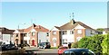
New houses in Carbry Drive
This suburban estate is located along the A29 Darkley Road.
Image: © Eric Jones
Taken: 2 Jun 2016
0.24 miles