IMAGES TAKEN NEAR TO
Priestbush Road, ARMAGH, BT60 2TP
Introduction
This page details the photographs taken nearby to Priestbush Road, BT60 2TP by members of the Geograph project.
The Geograph project started in 2005 with the aim of publishing, organising and preserving representative images for every square kilometre of Great Britain, Ireland and the Isle of Man.

There are currently over 7.5m images from over14,400 individuals and you can help contribute to the project by visiting https://www.geograph.org.uk
Image Map
Images are licensed for reuse under creativecommons.org/licenses/by-sa/2.0
Notes
- Clicking on the map will re-center to the selected point.
- The higher the marker number, the further away the image location is from the centre of the postcode.
Image Listing (5 Images Found)
Images are licensed for reuse under creativecommons.org/licenses/by-sa/2.0
Image
Details
Distance
2
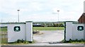
The grounds of Saint Killian's Gaelic Athletic Club, Whitecross
Image: © Eric Jones
Taken: 16 May 2014
0.19 miles
3
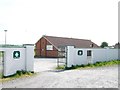
The club house of Whitecross' Saint Killian's Gaelic Athletic Club
The club which plays in green and white strip was established in 1904.
http://en.wikipedia.org/wiki/St._Killian's_GAC
Image: © Eric Jones
Taken: 16 May 2014
0.20 miles
4
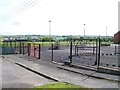
Children's play ground at Saint Killian's Gaelic Athletic Club
The GAA pitch can be seen in the middle ground.
Image: © Eric Jones
Taken: 16 May 2014
0.22 miles
5
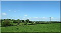
Drumlin topography north of the Whitecross-Kingsmills road
Image: © Eric Jones
Taken: 3 Jun 2016
0.22 miles