IMAGES TAKEN NEAR TO
Tassagh Road, ARMAGH, BT60 2RT
Introduction
This page details the photographs taken nearby to Tassagh Road, BT60 2RT by members of the Geograph project.
The Geograph project started in 2005 with the aim of publishing, organising and preserving representative images for every square kilometre of Great Britain, Ireland and the Isle of Man.

There are currently over 7.5m images from over14,400 individuals and you can help contribute to the project by visiting https://www.geograph.org.uk
Image Map
Images are licensed for reuse under creativecommons.org/licenses/by-sa/2.0
Notes
- Clicking on the map will re-center to the selected point.
- The higher the marker number, the further away the image location is from the centre of the postcode.
Image Listing (8 Images Found)
Images are licensed for reuse under creativecommons.org/licenses/by-sa/2.0
Image
Details
Distance
1
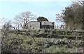
Farm Access Bridge
This old farm access bridge, just north of Annvale Green, crosses a cutting of the disused railway from Keady to Armagh. The railway opened in 1909 and closed in 1957. To read more visit https://en.wikipedia.org/wiki/Castleblayney,_Keady_and_Armagh_Railway
Image: © Sean Davis
Taken: 22 Mar 2020
0.17 miles
2
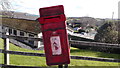
Post Box
Sad looking Royal Mail Postbox on the Tassagh Road at Annvale. However, it still seems to be in use.
Image: © Sean Davis
Taken: 4 Mar 2020
0.20 miles
3
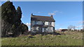
Derelict House
Derelict house on the Tassagh Road at Annvale, Keady.
Image: © Sean Davis
Taken: 4 Mar 2020
0.20 miles
4
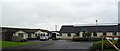
Keady Day Centre and Health Clinic
On the Annvale Road in Keady - recently extended.
Image: © Dean Molyneaux
Taken: 14 Aug 2009
0.20 miles
5
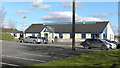
Keady Day Care Clinic
Keady Day Care Clinic and Health Centre from Annvale Road.
Image: © Sean Davis
Taken: 4 Mar 2020
0.21 miles
6
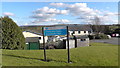
Keady Day Care Centre and Health Clinic
The sign for Keady Day Care Clinic and Health Centre, with the clinic behind it.
Image: © Sean Davis
Taken: 4 Mar 2020
0.21 miles
7
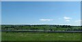
Drumlins south of the B3 (Keady-Tassagh road)
Image: © Eric Jones
Taken: 2 Jun 2016
0.23 miles
8
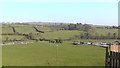
Clea Valley at Annvale
Many acres of the fields at the base of this small river valley provided the bleaching greens of Annvale Mills during the 19th and early 20th centuries. At its peak, Annvale had over 20 mill buildings and employed hundreds. At present the fields are used for horses and farming. However, there are plans to build housing on much of this land.
Image: © Sean Davis
Taken: 22 Mar 2020
0.25 miles