IMAGES TAKEN NEAR TO
Newtownhamilton Road, ARMAGH, BT60 2PL
Introduction
This page details the photographs taken nearby to Newtownhamilton Road, BT60 2PL by members of the Geograph project.
The Geograph project started in 2005 with the aim of publishing, organising and preserving representative images for every square kilometre of Great Britain, Ireland and the Isle of Man.

There are currently over 7.5m images from over14,400 individuals and you can help contribute to the project by visiting https://www.geograph.org.uk
Image Map
Images are licensed for reuse under creativecommons.org/licenses/by-sa/2.0
Notes
- Clicking on the map will re-center to the selected point.
- The higher the marker number, the further away the image location is from the centre of the postcode.
Image Listing (3 Images Found)
Images are licensed for reuse under creativecommons.org/licenses/by-sa/2.0
Image
Details
Distance
1
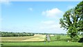
Road linking the B31 (Newtownhamilton) road and the A29 (Keady) road
This narrow lane is also known as the Newtownhamilton Road.
Image: © Eric Jones
Taken: 3 Jun 2016
0.20 miles
2
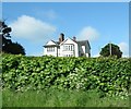
Farmhouse on a drumlin above the B31 (Newtownhamilton) road
Image: © Eric Jones
Taken: 3 Jun 2016
0.21 miles
3
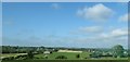
Undulating countryside between the B31 (Newtownhamilton) road and the A29 (Keady) road
The nets on the extreme right are those of the Hill View Lodge Golf Driving Range.
Image: © Eric Jones
Taken: 3 Jun 2016
0.21 miles