IMAGES TAKEN NEAR TO
Blairmont Road, ARMAGH, BT60 2LZ
Introduction
This page details the photographs taken nearby to Blairmont Road, BT60 2LZ by members of the Geograph project.
The Geograph project started in 2005 with the aim of publishing, organising and preserving representative images for every square kilometre of Great Britain, Ireland and the Isle of Man.

There are currently over 7.5m images from over14,400 individuals and you can help contribute to the project by visiting https://www.geograph.org.uk
Image Map
Images are licensed for reuse under creativecommons.org/licenses/by-sa/2.0
Notes
- Clicking on the map will re-center to the selected point.
- The higher the marker number, the further away the image location is from the centre of the postcode.
Image Listing (3 Images Found)
Images are licensed for reuse under creativecommons.org/licenses/by-sa/2.0
Image
Details
Distance
1
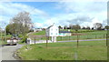
Blairmont Road from A29
Blairmont Road at Tassagh Townland from A29, Armagh to Keady Road.
Image: © Sean Davis
Taken: 1 May 2020
0.05 miles
2
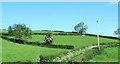
Field access lane off the A29
This road faces the northern entrance to the Tassagh-bound Blairmont Road.
Image: © Eric Jones
Taken: 2 Jun 2016
0.08 miles
3

Traditional farm buildings on the A29 south of the Dundrum Road junction
Image: © Eric Jones
Taken: 2 Jun 2016
0.17 miles