IMAGES TAKEN NEAR TO
Ballynagalliagh Road, ARMAGH, BT60 2LX
Introduction
This page details the photographs taken nearby to Ballynagalliagh Road, BT60 2LX by members of the Geograph project.
The Geograph project started in 2005 with the aim of publishing, organising and preserving representative images for every square kilometre of Great Britain, Ireland and the Isle of Man.

There are currently over 7.5m images from over14,400 individuals and you can help contribute to the project by visiting https://www.geograph.org.uk
Image Map
Images are licensed for reuse under creativecommons.org/licenses/by-sa/2.0
Notes
- Clicking on the map will re-center to the selected point.
- The higher the marker number, the further away the image location is from the centre of the postcode.
Image Listing (20 Images Found)
Images are licensed for reuse under creativecommons.org/licenses/by-sa/2.0
Image
Details
Distance
1
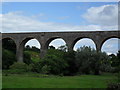
Tassagh Viaduct
This viaduct near Tassagh has a history of misfortune. It was constructed in 1910 to provide a link between Armagh and the County Monaghan town of Castleblayney. However with the partition in 1922, the costly necessity of customs inspections forced the line beyond Keady's closure in 1923. The line to Keady eventually suffered the same fate, closing in 1932 after just 22 years. See also Image
Image: © Dean Molyneaux
Taken: 19 Jul 2009
0.08 miles
2
Tassagh Viaduct and Mill
The old Railway Viaduct across the Callan Valley at Tassagh. The railway from Armagh to Keady opened in 1909 and closed in 1957. It is said that 11 construction workers dies building the 11 arch viaduct, one for each arch. The viaduct is now a listed building. The Mill sits next to the River Callan and was used as a beetling mill in the linen industry. The photo is taken from an unclassified road on "The Beetlers' Trail" an 8 mile walk around some of the Keady mills. See https://en.wikipedia.org/wiki/Tassagh_Viaduct
Image: © Sean Davis
Taken: 20 Sep 2019
0.10 miles
3
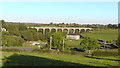
Tassagh Viaduct from Below
Tassagh Viaduct from Dundrum Road. The 11 arch viaduct carried the Armagh to Keady Railway over the Callan Valley from 1909 until trains ceased in 1957. See https://en.wikipedia.org/wiki/Tassagh_Viaduct
Image: © Sean Davis
Taken: 20 Sep 2019
0.10 miles
4
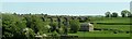
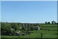
The Ballynagalliagh Road bridge over the Callan River
The image taken from the Keady Road also shows (in the adjoining square) the Tassagh linen mill and the Tassagh Viaduct.
Image: © Eric Jones
Taken: 2 Jun 2016
0.11 miles
5
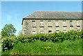
The Tassagh Linen Mill
This disused linen mill lies in the shadow of the Tassagh Viaduct.
Image: © Eric Jones
Taken: 2 Jun 2016
0.11 miles
7
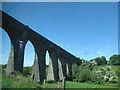
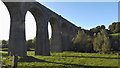
The northern section of the Tassagh Viaduct
There is no public access to the viaduct its track bed being blocked off at both ends.
Image: © Eric Jones
Taken: 2 Jun 2016
0.13 miles
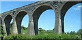
9
The Tassagh Viaduct from the Keady Road
The viaduct spans the Callan River Valley.
Image: © Eric Jones
Taken: 2 Jun 2016
0.14 miles
10
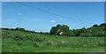
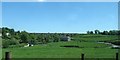
Hay field sloping down to the River Callan from the direction of the Keady Road
Image: © Eric Jones
Taken: 2 Jun 2016
0.14 miles