IMAGES TAKEN NEAR TO
Primates Manor, ARMAGH, BT60 2LR
Introduction
This page details the photographs taken nearby to Primates Manor, BT60 2LR by members of the Geograph project.
The Geograph project started in 2005 with the aim of publishing, organising and preserving representative images for every square kilometre of Great Britain, Ireland and the Isle of Man.

There are currently over 7.5m images from over14,400 individuals and you can help contribute to the project by visiting https://www.geograph.org.uk
Image Map
Images are licensed for reuse under creativecommons.org/licenses/by-sa/2.0
Notes
- Clicking on the map will re-center to the selected point.
- The higher the marker number, the further away the image location is from the centre of the postcode.
Image Listing (13 Images Found)
Images are licensed for reuse under creativecommons.org/licenses/by-sa/2.0
Image
Details
Distance
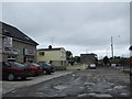
1
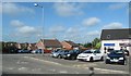
Car park serving a unit of businesses at the junction of Keady Road and Rock Road
Image: © Eric Jones
Taken: 3 Jun 2016
0.04 miles
2
Armagh, County Armagh
The Cathedral can be seen in the distance
Image: © Kenneth Allen
Taken: 7 Nov 2007
0.04 miles
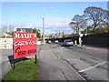
3
Rock Road, Armagh
Lots of new developments on the city out-skirts.
Image: © Kenneth Allen
Taken: 7 Nov 2007
0.06 miles
4
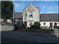
Primate's Cottages, Armagh
These are located on the Keady Road. There are 7 modernised cottages in this Victorian terrace.
Image: © Eric Jones
Taken: 3 Jun 2016
0.08 miles
5
Southern outskirts of Armagh City
Image: © Jonathan Billinger
Taken: 17 May 2007
0.08 miles
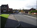
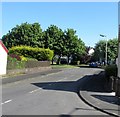
6
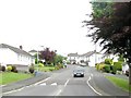
Keady Road from the Monaghan Road junction
Image: © Eric Jones
Taken: 2 Jun 2016
0.11 miles
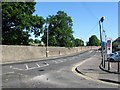
8
Mullanstown Park off the Monaghan Road, Armagh
Image: © Eric Jones
Taken: 2 Jun 2016
0.15 miles
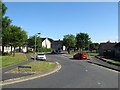
9
Greenpark Manor, Armagh
This is an area of new housing in the western suburbs of Armagh. The image was taken from the A3 (Monaghan Road).
Image: © Eric Jones
Taken: 4 Jun 2016
0.16 miles
10
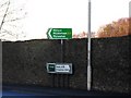
Signs, Irish Street, Armagh
At the junction with the Monaghan Road and the Keady Road. The wall encloses The Palace's grounds.
Image: © Dean Molyneaux
Taken: 27 Dec 2009
0.19 miles