IMAGES TAKEN NEAR TO
Carrickananny Road, ARMAGH, BT60 2JR
Introduction
This page details the photographs taken nearby to Carrickananny Road, BT60 2JR by members of the Geograph project.
The Geograph project started in 2005 with the aim of publishing, organising and preserving representative images for every square kilometre of Great Britain, Ireland and the Isle of Man.

There are currently over 7.5m images from over14,400 individuals and you can help contribute to the project by visiting https://www.geograph.org.uk
Image Map
Images are licensed for reuse under creativecommons.org/licenses/by-sa/2.0
Notes
- Clicking on the map will re-center to the selected point.
- The higher the marker number, the further away the image location is from the centre of the postcode.
Image Listing (25 Images Found)
Images are licensed for reuse under creativecommons.org/licenses/by-sa/2.0
Image
Details
Distance
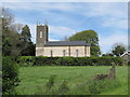
1
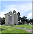
St Luke's Church, Carrickananny, Belleek
The image was taken from Carrickananny Road.
Image: © Eric Jones
Taken: 16 May 2014
0.04 miles
2
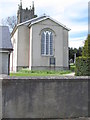
St Luke's CoI Parish Church, Carrickananny
Image: © Eric Jones
Taken: 16 May 2014
0.04 miles
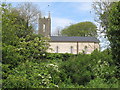
3
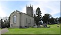
St Luke's Church, Carrickananny, Belleek
This is one of three Anglican churches in the parish of Newtownhamilton. The other two are: St John, Newtownhamilton and St Luke's, Ballymoyer (Whitecross).
http://armagh.anglican.org/index.php/parishes/newtownhamilton/
Image: © Eric Jones
Taken: 16 May 2014
0.04 miles
4
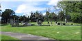
The graveyard at St Luke's CoI Church, Belleek
Image: © Eric Jones
Taken: 16 May 2014
0.05 miles
5
St Luke's CoI Parish Church, Carrickananny, Belleek
This one of three Anglican churches in the parish of Newtownhamilton. The other two churches are St John, Newtownhamilton and St Luke's Ballymoyer (Whitecross).
http://armagh.anglican.org/index.php/parishes/newtownhamilton/
Image: © Eric Jones
Taken: 16 May 2014
0.05 miles
6
St Luke's Anglican Church, Carrickananny
This image was taken from the Carrickananny Road.
Image: © Eric Jones
Taken: 16 May 2014
0.05 miles
7
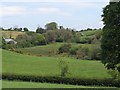
View across the valley towards the tower of St Luke's Carrickananny
Image: © Eric Jones
Taken: 16 May 2014
0.07 miles
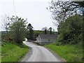
8
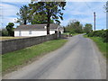
Carrickananny Road approaching its junction with minor road leading to Ballymoyer Road
The building this side of the junction is the Belleek Orange Hall - the home of the Belleek Bible and Crown Defenders L.O.L No 528. The first hall on this site was opened in 1926. During the Troubles the hall was attacked on a number of occasions. In 1969 it was damaged in an arson attack and then in 1970, 1971, and 1974 it was bombed. Finally, in 1995, the hall was burnt to the ground. A new and extended hall was then built which was opened in 1996.
Image: © Eric Jones
Taken: 16 May 2014
0.08 miles
9
Approaching Belleek Orange Hall from the north along Carrickananny Road
Image: © Eric Jones
Taken: 16 May 2014
0.09 miles
10
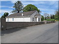
Belleek Orange Hall
The Orange Hall is situated about a mile north of the predominantly Nationalist village of Belleek.
Image: © Eric Jones
Taken: 16 May 2014
0.09 miles