IMAGES TAKEN NEAR TO
Mowhan Road, ARMAGH, BT60 2JJ
Introduction
This page details the photographs taken nearby to Mowhan Road, BT60 2JJ by members of the Geograph project.
The Geograph project started in 2005 with the aim of publishing, organising and preserving representative images for every square kilometre of Great Britain, Ireland and the Isle of Man.

There are currently over 7.5m images from over14,400 individuals and you can help contribute to the project by visiting https://www.geograph.org.uk
Image Map
Images are licensed for reuse under creativecommons.org/licenses/by-sa/2.0
Notes
- Clicking on the map will re-center to the selected point.
- The higher the marker number, the further away the image location is from the centre of the postcode.
Image Listing (6 Images Found)
Images are licensed for reuse under creativecommons.org/licenses/by-sa/2.0
Image
Details
Distance
1
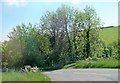
The western end of Tullyherron Road
The image was taken from Mowhan Road.
Image: © Eric Jones
Taken: 1 Jun 2016
0.11 miles
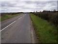
3
House on Creggan West Road
Creggan West Road runs east from Mowhan Road.
Image: © Eric Jones
Taken: 1 Jun 2016
0.16 miles
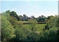
5
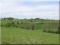
Dairy Farm north of Whitecross
A Friesian/Holstein milking herd can be seen in the fields below the farm buildings.
Image: © Eric Jones
Taken: 16 May 2014
0.19 miles
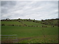
6
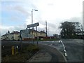
Whitecross, County Armagh
Whitecross Village at the junction of the Mowhan and Kingsmill Roads.
Image: © Dean Molyneaux
Taken: 15 Jan 2009
0.25 miles