IMAGES TAKEN NEAR TO
Mowhan Road, ARMAGH, BT60 2JE
Introduction
This page details the photographs taken nearby to Mowhan Road, BT60 2JE by members of the Geograph project.
The Geograph project started in 2005 with the aim of publishing, organising and preserving representative images for every square kilometre of Great Britain, Ireland and the Isle of Man.

There are currently over 7.5m images from over14,400 individuals and you can help contribute to the project by visiting https://www.geograph.org.uk
Image Map
Images are licensed for reuse under creativecommons.org/licenses/by-sa/2.0
Notes
- Clicking on the map will re-center to the selected point.
- The higher the marker number, the further away the image location is from the centre of the postcode.
Image Listing (7 Images Found)
Images are licensed for reuse under creativecommons.org/licenses/by-sa/2.0
Image
Details
Distance
5
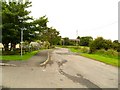
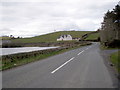
Springhill Road, Glenanne
A narrow and twisty road leading from the Mowhan Road in Glenanne village to Ballylane.
Image: © Dean Molyneaux
Taken: 14 Aug 2009
0.18 miles
6
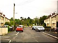
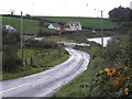
Mossfield, Glenanne
A small housing estate in the village of Glenanne.
Image: © Dean Molyneaux
Taken: 14 Aug 2009
0.20 miles
7
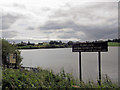
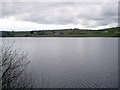
Shaws Lake
Located on the B134 as one travels north from Whitecross village towards Mowhan.
Image: © Terry Stewart
Taken: 19 Aug 2007
0.22 miles