IMAGES TAKEN NEAR TO
The Braes, ARMAGH, BT60 2FG
Introduction
This page details the photographs taken nearby to The Braes, BT60 2FG by members of the Geograph project.
The Geograph project started in 2005 with the aim of publishing, organising and preserving representative images for every square kilometre of Great Britain, Ireland and the Isle of Man.

There are currently over 7.5m images from over14,400 individuals and you can help contribute to the project by visiting https://www.geograph.org.uk
Image Map
Images are licensed for reuse under creativecommons.org/licenses/by-sa/2.0
Notes
- Clicking on the map will re-center to the selected point.
- The higher the marker number, the further away the image location is from the centre of the postcode.
Image Listing (2 Images Found)
Images are licensed for reuse under creativecommons.org/licenses/by-sa/2.0
Image
Details
Distance
1
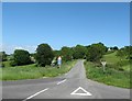
Single track road linking the A28 and Ballydogherty Road
Image: © Eric Jones
Taken: 3 Jun 2016
0.20 miles
2
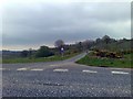
Ballygorman Townland, Loughgilly
This is where a part of the Ballydogherty Road meets the A28 Gosford Road in the townland of Ballygorman - near Loughgilly. The road is unusual for the area, being marked as "Single Track without Passing Places".
Image: © Dean Molyneaux
Taken: 17 Apr 2009
0.22 miles