IMAGES TAKEN NEAR TO
Neills Villas, ARMAGH, BT60 2DX
Introduction
This page details the photographs taken nearby to Neills Villas, BT60 2DX by members of the Geograph project.
The Geograph project started in 2005 with the aim of publishing, organising and preserving representative images for every square kilometre of Great Britain, Ireland and the Isle of Man.

There are currently over 7.5m images from over14,400 individuals and you can help contribute to the project by visiting https://www.geograph.org.uk
Image Map
Images are licensed for reuse under creativecommons.org/licenses/by-sa/2.0
Notes
- Clicking on the map will re-center to the selected point.
- The higher the marker number, the further away the image location is from the centre of the postcode.
Image Listing (5 Images Found)
Images are licensed for reuse under creativecommons.org/licenses/by-sa/2.0
Image
Details
Distance
1
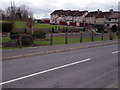
Children's Play Area, Loughgilly Village
Image: © P Flannagan
Taken: 18 Mar 2008
0.07 miles
2

Waste water treatment works at Loughgilly
This is located on the northern side of the Glenanne road.
Image: © Eric Jones
Taken: 3 Jun 2016
0.08 miles
3
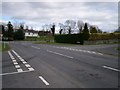
Junction of the Glenanne Road and Neill's Avenue, Loughgilly
Beyond the "Give Way" sign is the A28 main road, Armagh to Newry.
Image: © P Flannagan
Taken: 18 Mar 2008
0.08 miles
4
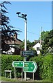
Security cameras at the Glenanne Road junction on the A28 at Loughgilly
Image: © Eric Jones
Taken: 3 Jun 2016
0.13 miles
5
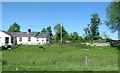
Sheep grazing paddock alongside the A28 at Loughgilly
On the day when this image was taken the only clue to its use was discarded wool. The Street View image of 2011 shows sheep grazing on this paddock.
http://www.instantstreetview.com/@54.274493,-6.466845,37.46h,17.02p,0.19z
Image: © Eric Jones
Taken: 3 Jun 2016
0.13 miles