IMAGES TAKEN NEAR TO
Glenanne Road, ARMAGH, BT60 2BX
Introduction
This page details the photographs taken nearby to Glenanne Road, BT60 2BX by members of the Geograph project.
The Geograph project started in 2005 with the aim of publishing, organising and preserving representative images for every square kilometre of Great Britain, Ireland and the Isle of Man.

There are currently over 7.5m images from over14,400 individuals and you can help contribute to the project by visiting https://www.geograph.org.uk
Image Map
Images are licensed for reuse under creativecommons.org/licenses/by-sa/2.0
Notes
- Clicking on the map will re-center to the selected point.
- The higher the marker number, the further away the image location is from the centre of the postcode.
Image Listing (5 Images Found)
Images are licensed for reuse under creativecommons.org/licenses/by-sa/2.0
Image
Details
Distance
1

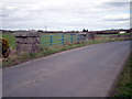
Farm buildings overlooking the Glenanne Road
The buildings are located on a drumlin overlooking the Cusher River flood plain.
Image: © Eric Jones
Taken: 3 Jun 2016
0.16 miles
2
Road Bridge over the River Cusher, Loughgilly
Note the contrast of the old Granite pillars joined by modern steel safety railing.
Image: © P Flannagan
Taken: 18 Mar 2008
0.17 miles
3
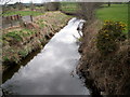
Cusher River, Loughgilly
Photograph taken from the road bridge on the Glenanne Road.
Image: © P Flannagan
Taken: 18 Mar 2008
0.18 miles
4

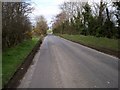
Minor road linking Bessbrook Road with the A28 (Gosford Road)
Vehicles weighing more than 3 tons are not allowed to travel the full length of this road because of the presence of a weak bridge spanning the Crusher River in square Image
http://www.instantstreetview.com/@54.276887,-6.479352,170.48h,-3.15p,1z
Image: © Eric Jones
Taken: 3 Jun 2016
0.24 miles