IMAGES TAKEN NEAR TO
Forest View, ARMAGH, BT60 1TB
Introduction
This page details the photographs taken nearby to Forest View, BT60 1TB by members of the Geograph project.
The Geograph project started in 2005 with the aim of publishing, organising and preserving representative images for every square kilometre of Great Britain, Ireland and the Isle of Man.

There are currently over 7.5m images from over14,400 individuals and you can help contribute to the project by visiting https://www.geograph.org.uk
Image Map
Images are licensed for reuse under creativecommons.org/licenses/by-sa/2.0
Notes
- Clicking on the map will re-center to the selected point.
- The higher the marker number, the further away the image location is from the centre of the postcode.
Image Listing (14 Images Found)
Images are licensed for reuse under creativecommons.org/licenses/by-sa/2.0
Image
Details
Distance
1
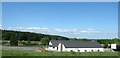
Tandragee Road at its junction with the A28
The Markethill suburb of Forest Park lies to the south-west of the A28.
Image: © Eric Jones
Taken: 3 Jun 2016
0.06 miles
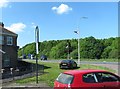
4
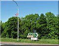
Direction signs and the Union Flag at the B3 junction on the A28 at Markethill
Markethill is a predominantly Loyalist town, where in the 2011 Census 80.14% belonged to or were brought up in a 'Protestant and Other Christian (including Christian related)' religion.
Image: © Eric Jones
Taken: 3 Jun 2016
0.11 miles
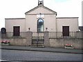
5
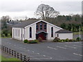
Markethill Free Presbyterian Church
This is accessed from the Tandragee Road. Construction of this church was completed in 1992. The architectural style is characteristic of that of most Free Presbyterian churches in Ulster and beyond.
http://www.freepresbyterian.org/churches/
Image: © Eric Jones
Taken: 3 Jun 2016
0.12 miles
6
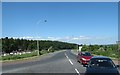
The A28 by-pass at Markethill
The image was taken in NE direction from the B3 junction.
Image: © Eric Jones
Taken: 3 Jun 2016
0.12 miles
7
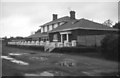
Markethill Railway Station
Markethill Railway station located on the closed Armagh to Newry railway line.
Image: © Wilson Adams
Taken: Unknown
0.15 miles
8
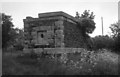
Water Tower, Stone base
The remains of the water tower that stood at the Newry end of Markethill station,
Image: © Wilson Adams
Taken: Unknown
0.15 miles
9
Church of Ireland Chapel of Ease, Markethill.
Consecrated in 1859.
Image: © P Flannagan
Taken: 25 Aug 2007
0.15 miles
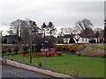
10
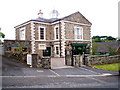
The Court House Restaurant, Markethill
It is situated in the Main Street. The former Markethill Court House was built in 1842 of blackstone with a simple pediment and granite quoins and dressings. A simple but quite grand two storey "T" shaped building. The architect was Thomas Duff. It was repaired and converted to a restaurant, community centre and creche in 2002.
Image: © P Flannagan
Taken: 25 Aug 2007
0.15 miles