IMAGES TAKEN NEAR TO
Pinley Green, ARMAGH, BT60 1RX
Introduction
This page details the photographs taken nearby to Pinley Green, BT60 1RX by members of the Geograph project.
The Geograph project started in 2005 with the aim of publishing, organising and preserving representative images for every square kilometre of Great Britain, Ireland and the Isle of Man.

There are currently over 7.5m images from over14,400 individuals and you can help contribute to the project by visiting https://www.geograph.org.uk
Image Map
Images are licensed for reuse under creativecommons.org/licenses/by-sa/2.0
Notes
- Clicking on the map will re-center to the selected point.
- The higher the marker number, the further away the image location is from the centre of the postcode.
Image Listing (3 Images Found)
Images are licensed for reuse under creativecommons.org/licenses/by-sa/2.0
Image
Details
Distance
1
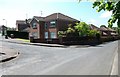
An estate of recently built houses in Eden Drive
The image shows houses at the junction of Eden Drive and Seaboughan Road
Image: © Eric Jones
Taken: 1 Jun 2016
0.20 miles
2
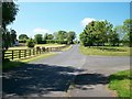
View SW along Seaboughan Road, Markethill
Image: © Eric Jones
Taken: 1 Jun 2016
0.20 miles
3
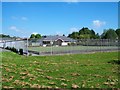
Recreation grounds on Seaboughan Road, Markethill
Image: © Eric Jones
Taken: 1 Jun 2016
0.23 miles