IMAGES TAKEN NEAR TO
Green Park Drive, ARMAGH, BT60 1PX
Introduction
This page details the photographs taken nearby to Green Park Drive, BT60 1PX by members of the Geograph project.
The Geograph project started in 2005 with the aim of publishing, organising and preserving representative images for every square kilometre of Great Britain, Ireland and the Isle of Man.

There are currently over 7.5m images from over14,400 individuals and you can help contribute to the project by visiting https://www.geograph.org.uk
Image Map
Images are licensed for reuse under creativecommons.org/licenses/by-sa/2.0
Notes
- Clicking on the map will re-center to the selected point.
- The higher the marker number, the further away the image location is from the centre of the postcode.
Image Listing (41 Images Found)
Images are licensed for reuse under creativecommons.org/licenses/by-sa/2.0
Image
Details
Distance
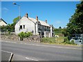
1
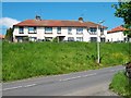
Houses in Green Park Avenue, Markethill
The image was taken from the old railway goods yard
Image: © Eric Jones
Taken: 1 Jun 2016
0.03 miles
2
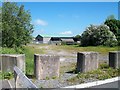
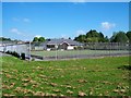
The disused railway goods yard at Markethill
The goods yards became redundant when the GNR Armagh to Newry line finally closed in 1955.
Image: © Eric Jones
Taken: 1 Jun 2016
0.06 miles
3
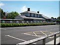
The converted former Markethill Railway Station
Markethill railway station dates from 1864 and was served by the Newry to Armagh GNR line. The station was closed for passenger traffic as early as 1933 but still handled goods until 1955. The station building has been converted into an elegant house.
Image: © Eric Jones
Taken: 1 Jun 2016
0.06 miles
4
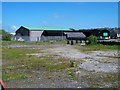
The derelict site of the former Markethill Station goods yard
The yard became redundant with the closure of the GNR Armagh-Newry line in 1955.
Image: © Eric Jones
Taken: 1 Jun 2016
0.07 miles
5
Recreation grounds on Seaboughan Road, Markethill
Image: © Eric Jones
Taken: 1 Jun 2016
0.11 miles
6
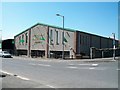
Alexander's of Markethill Furnishing
This is located on the SW side of the Coolmillish Road/B3 roundabout.
Image: © Eric Jones
Taken: 1 Jun 2016
0.11 miles
8
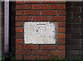
Bench Mark, Markethill
Cut bench mark on the wall of a shop on the Mowhan Road in Markethill.
An unusual example - the mark appears to have been cut into a stone block which was once part of another building. I assume that this was demolished and the builders retained the mark, building it into the brickwork of this replacement structure. According to modern maps (in the last 50 years), this mark has not been levelled, probably because it was disturbed from the original setting and thus unreliable. The only reference I can find to a mark at this location is one cut c1860 that had been levelled to 305.8 feet above sea level.
Image: © Rossographer
Taken: 12 Apr 2012
0.11 miles
9
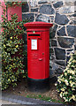
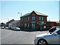
Postbox, Markethill
Elizabeth II pillar box (BT60 102) located outside Markethill Post Office, which is now incorporated into the JD Hunter & Co. supermarket in the village http://www.jdhunter.co.uk/ .
Image: © Rossographer
Taken: 12 Apr 2012
0.11 miles
10
House under construction on Coolmillish Road, Markethill
Image: © Eric Jones
Taken: 1 Jun 2016
0.12 miles