IMAGES TAKEN NEAR TO
Ratarnet Road, ARMAGH, BT60 1LG
Introduction
This page details the photographs taken nearby to Ratarnet Road, BT60 1LG by members of the Geograph project.
The Geograph project started in 2005 with the aim of publishing, organising and preserving representative images for every square kilometre of Great Britain, Ireland and the Isle of Man.

There are currently over 7.5m images from over14,400 individuals and you can help contribute to the project by visiting https://www.geograph.org.uk
Image Map
Images are licensed for reuse under creativecommons.org/licenses/by-sa/2.0
Notes
- Clicking on the map will re-center to the selected point.
- The higher the marker number, the further away the image location is from the centre of the postcode.
Image Listing (2 Images Found)
Images are licensed for reuse under creativecommons.org/licenses/by-sa/2.0
Image
Details
Distance
1
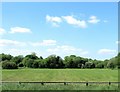
Harvested hay field on the north side of the A28
Image: © Eric Jones
Taken: 3 Jun 2016
0.22 miles
2
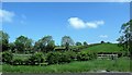
Rolling countryside north of the A28
This is a tiny section of the North of Ireland drumlin belt which extends through Down and Monaghan to Co Cavan.
Image: © Eric Jones
Taken: 1 Jun 2016
0.24 miles