IMAGES TAKEN NEAR TO
Markethill Road, ARMAGH, BT60 1LE
Introduction
This page details the photographs taken nearby to Markethill Road, BT60 1LE by members of the Geograph project.
The Geograph project started in 2005 with the aim of publishing, organising and preserving representative images for every square kilometre of Great Britain, Ireland and the Isle of Man.

There are currently over 7.5m images from over14,400 individuals and you can help contribute to the project by visiting https://www.geograph.org.uk
Image Map
Images are licensed for reuse under creativecommons.org/licenses/by-sa/2.0
Notes
- Clicking on the map will re-center to the selected point.
- The higher the marker number, the further away the image location is from the centre of the postcode.
Image Listing (3 Images Found)
Images are licensed for reuse under creativecommons.org/licenses/by-sa/2.0
Image
Details
Distance
1
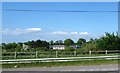
Modern farmhouse off the A28 (Markethill Road)
This is located on an unnamed minor road linking the A28 and the A51
Image: © Eric Jones
Taken: 3 Jun 2016
0.17 miles
2
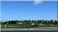
Farmhouse and buildings in Edenknappagh TD
These are located on a side road off the A28 road.
Image: © Eric Jones
Taken: 1 Jun 2016
0.22 miles
3
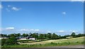
Farm in the Townland of Edenkappagh
The image was taken from the A28 (Markethill Road)
Image: © Eric Jones
Taken: 3 Jun 2016
0.23 miles