IMAGES TAKEN NEAR TO
Lowrys Avenue, ARMAGH, BT60 1BF
Introduction
This page details the photographs taken nearby to Lowrys Avenue, BT60 1BF by members of the Geograph project.
The Geograph project started in 2005 with the aim of publishing, organising and preserving representative images for every square kilometre of Great Britain, Ireland and the Isle of Man.

There are currently over 7.5m images from over14,400 individuals and you can help contribute to the project by visiting https://www.geograph.org.uk
Image Map
Images are licensed for reuse under creativecommons.org/licenses/by-sa/2.0
Notes
- Clicking on the map will re-center to the selected point.
- The higher the marker number, the further away the image location is from the centre of the postcode.
Image Listing (10 Images Found)
Images are licensed for reuse under creativecommons.org/licenses/by-sa/2.0
Image
Details
Distance
1
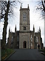
St Mark's Parish Church
The Church of Ireland Parish Church of Armagh was built in 1811.
Image: © Brian Shaw
Taken: 13 Feb 2006
0.14 miles
2
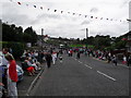
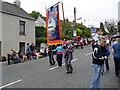
Hamiltonsbawn Road, Armagh
The Hamiltonsbawn Road in Armagh city - looking towards the centre at Drumadd. The crowd can be explained by the 2009 County Armagh Orange Order marches taking place on the day.
Image: © Dean Molyneaux
Taken: 13 Jul 2009
0.20 miles
3
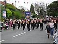
Twelfth parade, Hamiltonsbawn Road, Armagh
The Portadown District Loyal Orange Lodge (D.L.O.L. No. 1) return from the Demonstration Field on the Hamiltonsbawn Road to the city centre during the County Armagh 12th July parades.
Image: © Dean Molyneaux
Taken: 13 Jul 2009
0.21 miles
4

Twelfth parade, Hamiltonsbawn Road, Armagh (2)
The Loughgall District Loyal Orange Lodge (D.L.O.L. No. 2) return from the Demonstration Field on the Hamiltonsbawn Road to the city centre during the County Armagh 12th July parades.
Image: © Dean Molyneaux
Taken: 13 Jul 2009
0.21 miles
5
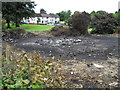
Remnants of Bonfire, Barrack Hill
The remnants of a bonfire on Barrack Hill in Armagh. It had been lit two days beforehand.
Image: © Dean Molyneaux
Taken: 13 Jul 2009
0.21 miles
6
Twelfth parade, Hamiltonsbawn Road, Armagh (3)
The Battlehill Orange Lodge, Portadown (L.O.L. No. 395) return from the Demonstration Field on the Hamiltonsbawn Road to the city centre during the County Armagh 12th July parades.
Image: © Dean Molyneaux
Taken: 13 Jul 2009
0.21 miles
7

Twelfth parade, Hamiltonsbawn Road, Armagh (4)
The Herbert Whitten Memorial Orange Lodge (L.O.L. No. 40) return from the Demonstration Field on the Hamiltonsbawn Road to the city centre during the County Armagh 12th July parades.
Image: © Dean Molyneaux
Taken: 13 Jul 2009
0.22 miles
8
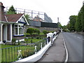
Bungalow by Gough Barracks
The military building in this view of Victoria Road is the Gough barracks which has been used for many years as an RUC/PSNI base and prior to that as a British Military base.
Image: © Jonathan Billinger
Taken: 17 May 2007
0.22 miles
9
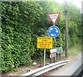
Road directions at the Drummad junction on the A3
Image: © Eric Jones
Taken: 4 Jun 2016
0.23 miles
10
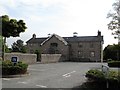
Building at the Armagh Community Hospital
Image: © Eric Jones
Taken: 4 Jun 2016
0.23 miles