IMAGES TAKEN NEAR TO
Rosemount Avenue, ARMAGH, BT60 1BB
Introduction
This page details the photographs taken nearby to Rosemount Avenue, BT60 1BB by members of the Geograph project.
The Geograph project started in 2005 with the aim of publishing, organising and preserving representative images for every square kilometre of Great Britain, Ireland and the Isle of Man.

There are currently over 7.5m images from over14,400 individuals and you can help contribute to the project by visiting https://www.geograph.org.uk
Image Map
Images are licensed for reuse under creativecommons.org/licenses/by-sa/2.0
Notes
- Clicking on the map will re-center to the selected point.
- The higher the marker number, the further away the image location is from the centre of the postcode.
Image Listing (6 Images Found)
Images are licensed for reuse under creativecommons.org/licenses/by-sa/2.0
Image
Details
Distance
1
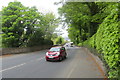
The A28 Markethill Road (3)
Further along and a bit greener but just as busy.
Image: © Robert Ashby
Taken: 11 May 2016
0.17 miles
2
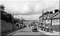
Entering Armagh, 1960
View NW on A28 Newry Road, from Markethill etc. In the distance is St Patrick's Cathedral.
Image: © Ben Brooksbank
Taken: 9 Aug 1960
0.18 miles
3
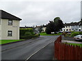
Drumadd Green, Armagh
Drumadd Green in Armagh's Folly estate. The sign in the centre marks the Folly estate's winning of 'Best Kept Housing Area' in 1992.
Image: © Dean Molyneaux
Taken: 13 Jul 2009
0.20 miles
4
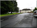
Killuney Drive, Armagh
Killuney Drive in Armagh's Folly Estate.
Image: © Dean Molyneaux
Taken: 13 Jul 2009
0.20 miles
5
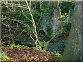
Ballynahone Corn Mill, Armagh
Ballynahone Mill, is located on a short footpath off Barrack Hill. The arch in the centre of the photo is where the waterwheel was located.
Image: © Mike Simms
Taken: 28 Jan 2017
0.22 miles
6
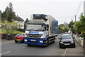
The A28 Markethill Road (2)
Same location with added traffic.
Image: © Robert Ashby
Taken: 11 May 2016
0.23 miles