IMAGES TAKEN NEAR TO
Ballygowan Road, BELFAST, BT5 7TZ
Introduction
This page details the photographs taken nearby to Ballygowan Road, BT5 7TZ by members of the Geograph project.
The Geograph project started in 2005 with the aim of publishing, organising and preserving representative images for every square kilometre of Great Britain, Ireland and the Isle of Man.

There are currently over 7.5m images from over14,400 individuals and you can help contribute to the project by visiting https://www.geograph.org.uk
Image Map
Images are licensed for reuse under creativecommons.org/licenses/by-sa/2.0
Notes
- Clicking on the map will re-center to the selected point.
- The higher the marker number, the further away the image location is from the centre of the postcode.
Image Listing (3 Images Found)
Images are licensed for reuse under creativecommons.org/licenses/by-sa/2.0
Image
Details
Distance
1
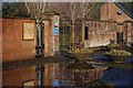
Cemetery entrance
This is the main entrance to Roselawn Cemetery and Crematorium, it is owned and managed by Belfast City Council.
Image: © Paul McIlroy
Taken: 10 Mar 2008
0.15 miles
2
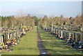
Roselawn Cemetery
Roselawn Cemetery is situated on the Crossnagreevy Road in the Castlereagh Hills to the south east of Belfast. It is owned and managed by Belfast City Council.
Image: © Paul McIlroy
Taken: 10 Mar 2008
0.19 miles
3
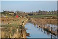
Flooded field
A night of heavy rain has caused this drainage ditch to overflow into the surrounding fields.
Image: © Paul McIlroy
Taken: 10 Mar 2008
0.22 miles