IMAGES TAKEN NEAR TO
Elsmere Heights, BELFAST, BT5 7TN
Introduction
This page details the photographs taken nearby to Elsmere Heights, BT5 7TN by members of the Geograph project.
The Geograph project started in 2005 with the aim of publishing, organising and preserving representative images for every square kilometre of Great Britain, Ireland and the Isle of Man.

There are currently over 7.5m images from over14,400 individuals and you can help contribute to the project by visiting https://www.geograph.org.uk
Image Map
Images are licensed for reuse under creativecommons.org/licenses/by-sa/2.0
Notes
- Clicking on the map will re-center to the selected point.
- The higher the marker number, the further away the image location is from the centre of the postcode.
Image Listing (15 Images Found)
Images are licensed for reuse under creativecommons.org/licenses/by-sa/2.0
Image
Details
Distance
1
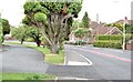
The Gilnahirk Road, Belfast - June 2015(1)
The view, inward, along the Gilnahirk Road as it approaches the end of built-up Belfast/the 30mph speed limit. The road on the left was, to the best of my knowledge, the original line and is now signposted as a private road.
Image: © Albert Bridge
Taken: 19 Jun 2015
0.06 miles
2
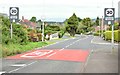
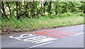
30 mph signs and road markings, Gilnahirk, Belfast - June 2015(1)
30 mph signs and road markings, on the Gilnahirk Road, at the start of built-up Belfast. This is a place where there is an abrupt change from a rural road (60 mph) to a suburban one
Image: © Albert Bridge
Taken: 19 Jun 2015
0.07 miles
3
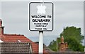
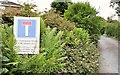
"Welcome to Gilnahirk" sign, Belfast (June 2015)
A “Welcome to Gilnahirk” sign just inside the 30mph zone on the Gilnahirk Road. The white patch was the arms of the old Castlereagh Borough Council.
Image: © Albert Bridge
Taken: 19 Jun 2015
0.07 miles
4
30 mph signs and road markings, Gilnahirk, Belfast - June 2015(2)
30 mph road markings and a “national speed limit applies” sign, on the Gilnahirk Road, at the start of built-up Belfast. This is a place where there is an abrupt change from a rural road (60 mph) to a suburban one. It also marks the current limit of development.
Image: © Albert Bridge
Taken: 19 Jun 2015
0.07 miles
5
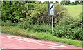
Road marking and rumble strips, Gilnahirk, Belfast (June 2015)
A “slow” marking and three red transverse rumble strips, on the Gilnahirk Road, approaching the start of the 30 mph zone. This is a place where there is an abrupt change from a rural road (60 mph) to a suburban one. The strips give an audible warning of the change.
Image: © Albert Bridge
Taken: 19 Jun 2015
0.09 miles
6
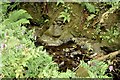
Stream, Gilnahirk, Belfast (June 2015)
A stream, not shown on the 1:50,000 map, on the eastern side of the Gilnahirk Road, inward from the Gilnahirk Road West. Mostly hidden by summer growth, only the sound of gurgling water made me aware of its presence.
Image: © Albert Bridge
Taken: 19 Jun 2015
0.11 miles
7
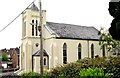
Gilnahirk Presbyterian church, Belfast - June 2015(1)
A church at the corner of the Gilnahirk and Rocky Roads. Not listed but described in detail here http://www.doeni.gov.uk/niea/content-databases-buildview?id=17100&js=true where the description includes “A symmetrical double-height rendered neo-Gothic Presbyterian Church with two-stage entrance tower (1910); dated 1845 with later alterations; built on the site of an earlier church. Rectangular on plan with two-stage entrance tower and large modern extension to rear”. Last seen in November 2005 Image Image shows the plaque above the entrance.
Image: © Albert Bridge
Taken: 19 Jun 2015
0.14 miles
8
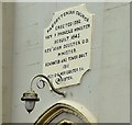
Gilnahirk Presbyterian church, Belfast - June 2015(2)
See Image A plaque, giving a short architectural history of the church, above the entrance. Last seen in November 2005 Image
Image: © Albert Bridge
Taken: 19 Jun 2015
0.14 miles
9
The Rocky Road, Gilnahirk, Belfast - June 2015(2)
See Image The “no through road” sign (just out of picture to the left in the previous photograph).
Image: © Albert Bridge
Taken: 19 Jun 2015
0.16 miles
10
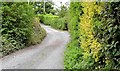
The Rocky Road, Gilnahirk, Belfast - June 2015(1)
See Image and Image The other Rocky Road – in this case it runs from the Gilnahirk Road (behind me) to the Upper Braniel Road but is not all public and definitely not suitable for motor vehicles. Image shows the “no through road” sign.
Image: © Albert Bridge
Taken: 19 Jun 2015
0.16 miles